Târguşor geodata
Târguşor (Constanța) is a seat of a second-order administrative division; located in Romania in Europe/Bucharest (GMT+3) time zone. With population of 2,937 people, there are 1827 cities with bigger population in this country. Compared to other cities in Romania, 86.8% of cities are located further ↑North; 98.4% of cities are located further ←West and 66.3% of cities have higher elevation than Târguşor. Note1


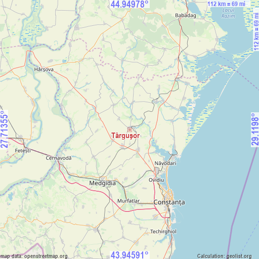
Târguşor GPS coordinates[2]
44° 27' 0" North, 28° 25' 0.012" East
| Map corner | latitude | longitude |
|---|---|---|
| Upper-left | 44.94978°, | 27.71355° |
| Center: | 44.45°, | 28.41667° |
| Lower-right: | 43.94591°, | 29.1198° |
| Map W x H: | 111.6×111.6 km | = 69.3×69.3mi |
| max Lat: | 48.23793° ⇑86.8% North |
| Târguşor: | 44.45° |
| min Lat: | ⇓13.2% South 43.65638° |
| min Long | Târguşor | max Long |
| 20.31667° | 28.41667° | 29.65403° |
| W 98.4%⇐ | ⇒1.6% E |
Elevation
Elevation of Târguşor is 142 m = 466 ft, and this is 112.9 m = 370 ft below average elevation for this country.
| Max E: |
1278 m = 4193 ft | 66.3% |
| Avg. | 254.9 m = 836 ft | |
| Târguşor | 142 m = 466 ft | |
Min E: |
-2 m = -7 ft | 33.7% |
See also: Romania elevation on elevation.city.
Geographical zone
Târguşor is located in North temperate zone (between Tropic of Cancer and the Arctic Circle). Distance of this Northern Tropic circle is 2336.5 km =1451.8 mi to South.| Distance of | km | miles | from Târguşor |
|---|---|---|---|
| North Pole | 5064.7 | 3147.1 | to North |
| Arctic Circle | 2458.8 | 1527.8 | to North |
| Tropic Cancer | 2336.5 | 1451.8 | to South |
| Equator | 4942.4 | 3071.1 | to South |


Nearby cities:
15 places around Târguşor: (largest is in red/bold)
• Băltăgești
18.1 km =11.2 mi,  281°
281°
• Cogealac
16.3 km =10.1 mi,  46°
46°
• Crucea
17.2 km =10.7 mi,  302°
302°
• Dorobanțu
8.4 km =5.2 mi,  238°
238°
• Grădina
11.8 km =7.3 mi,  6°
6°
• Mihail Kogălniceanu
9.7 km =6 mi,  159°
159°
• Nicolae Bălcescu
7.9 km =4.9 mi,  199°
199°
• Oituz
15.8 km =9.8 mi,  147°
147°
• Pantelimon
12.6 km =7.8 mi,  327°
327°
• Pantelimon de Jos
13.2 km =8.2 mi,  348°
348°
• Piatra
12.5 km =7.8 mi,  113°
113°
• Săcele
18.9 km =11.7 mi,  78°
78°
• Tariverde
19.3 km =12 mi, 49°
• Tepeș Vodă
14.1 km =8.8 mi,  268°
268°
• Tortoman
19.4 km =12.1 mi, 235°
Sources, notices
• [Note1] Compared only with cities in Romania existing in our database
• [Src1] Map data: © OpenStreetMap contributors (CC-BY-SA)
• [Src2] Other city data from geonames.org with taken over terms of usage.
• [Src3] Geographical zone / Annual Mean Temperature by Robert A. Rohde @ Wikipedia
