Cogealac geodata
Cogealac (Constanța) is a seat of a second-order administrative division; located in Romania in Europe/Bucharest (GMT+3) time zone. With population of 7,046 people, there are 406 cities with bigger population in this country. Compared to other cities in Romania, 84.2% of cities are located further ↑North; 98.9% of cities are located further ←West and 80.2% of cities have higher elevation than Cogealac. Note1


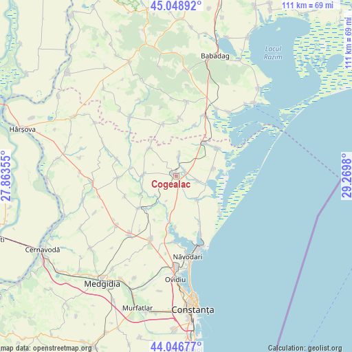
Cogealac GPS coordinates[2]
44° 33' 0" North, 28° 34' 0.012" East
| Map corner | latitude | longitude |
|---|---|---|
| Upper-left | 45.04892°, | 27.86355° |
| Center: | 44.55°, | 28.56667° |
| Lower-right: | 44.04677°, | 29.2698° |
| Map W x H: | 111.4×111.4 km | = 69.2×69.2mi |
| max Lat: | 48.23793° ⇑84.2% North |
| Cogealac: | 44.55° |
| min Lat: | ⇓15.8% South 43.65638° |
| min Long | Cogealac | max Long |
| 20.31667° | 28.56667° | 29.65403° |
| W 98.9%⇐ | ⇒1.1% E |
Elevation
Elevation of Cogealac is 94 m = 308 ft, and this is 160.9 m = 528 ft below average elevation for this country.
| Max E: |
1278 m = 4193 ft | 80.2% |
| Avg. | 254.9 m = 836 ft | |
| Cogealac | 94 m = 308 ft | |
Min E: |
-2 m = -7 ft | 19.8% |
See also: Romania elevation on elevation.city.
Geographical zone
Cogealac is located in North temperate zone (between Tropic of Cancer and the Arctic Circle). Distance of this Northern Tropic circle is 2347.6 km =1458.7 mi to South.| Distance of | km | miles | from Cogealac |
|---|---|---|---|
| North Pole | 5053.6 | 3140.2 | to North |
| Arctic Circle | 2447.7 | 1520.9 | to North |
| Tropic Cancer | 2347.6 | 1458.7 | to South |
| Equator | 4953.5 | 3078 | to South |


Nearby cities:
15 places around Cogealac: (largest is in red/bold)
• Beidaud
18.5 km =11.5 mi,  0°
0°
• Fântânele
7 km =4.3 mi,  6°
6°
• Grădina
10.7 km =6.6 mi,  273°
273°
• Istria
12 km =7.5 mi,  81°
81°
• Mihai Viteazu
13.1 km =8.1 mi,  44°
44°
• Nuntași
6.7 km =4.2 mi,  102°
102°
• Pantelimon
18.7 km =11.6 mi, 268°
• Pantelimon de Jos
14.6 km =9.1 mi,  277°
277°
• Piatra
16.1 km =10 mi,  181°
181°
• Râmnicu de Jos
12.5 km =7.8 mi,  314°
314°
• Sarighiol de Deal
17.2 km =10.7 mi,  345°
345°
• Săcele
9.9 km =6.2 mi,  138°
138°
• Tariverde
3.2 km =2 mi,  63°
63°
• Târguşor
16.3 km =10.1 mi,  226°
226°
• Vadu
17.4 km =10.8 mi,  129°
129°
Sources, notices
• [Note1] Compared only with cities in Romania existing in our database
• [Src1] Map data: © OpenStreetMap contributors (CC-BY-SA)
• [Src2] Other city data from geonames.org with taken over terms of usage.
• [Src3] Geographical zone / Annual Mean Temperature by Robert A. Rohde @ Wikipedia
