Crucea geodata
Crucea (Constanța) is a seat of a second-order administrative division; located in Romania in Europe/Bucharest (GMT+3) time zone. With population of 3,413 people, there are 1485 cities with bigger population in this country. Compared to other cities in Romania, 84.6% of cities are located further ↑North; 97.9% of cities are located further ←West and 81.4% of cities have higher elevation than Crucea. Note1


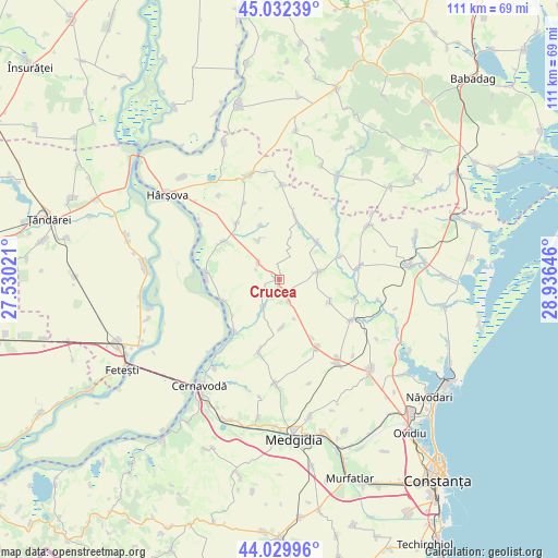
Crucea GPS coordinates[2]
44° 31' 59.988" North, 28° 13' 59.988" East
| Map corner | latitude | longitude |
|---|---|---|
| Upper-left | 45.03239°, | 27.53021° |
| Center: | 44.53333°, | 28.23333° |
| Lower-right: | 44.02996°, | 28.93646° |
| Map W x H: | 111.5×111.5 km | = 69.3×69.3mi |
| max Lat: | 48.23793° ⇑84.6% North |
| Crucea: | 44.53333° |
| min Lat: | ⇓15.4% South 43.65638° |
| min Long | Crucea | max Long |
| 20.31667° | 28.23333° | 29.65403° |
| W 97.9%⇐ | ⇒2.1% E |
Elevation
Elevation of Crucea is 90 m = 295 ft, and this is 164.9 m = 541 ft below average elevation for this country.
| Max E: |
1278 m = 4193 ft | 81.4% |
| Avg. | 254.9 m = 836 ft | |
| Crucea | 90 m = 295 ft | |
Min E: |
-2 m = -7 ft | 18.6% |
See also: Romania elevation on elevation.city.
Geographical zone
Crucea is located in North temperate zone (between Tropic of Cancer and the Arctic Circle). Distance of this Northern Tropic circle is 2345.7 km =1457.5 mi to South.| Distance of | km | miles | from Crucea |
|---|---|---|---|
| North Pole | 5055.4 | 3141.3 | to North |
| Arctic Circle | 2449.5 | 1522 | to North |
| Tropic Cancer | 2345.7 | 1457.5 | to South |
| Equator | 4951.6 | 3076.8 | to South |


Nearby cities:
15 places around Crucea: (largest is in red/bold)
• Băltăgești
6.4 km =4 mi,  209°
209°
• Dorobanțu
15.6 km =9.7 mi,  151°
151°
• Dunărea
14 km =8.7 mi,  220°
220°
• Grădina
16 km =9.9 mi,  81°
81°
• Horia
14.5 km =9 mi,  320°
320°
• Nicolae Bălcescu
20.5 km =12.7 mi,  144°
144°
• Pantelimon
7.9 km =4.9 mi, 79°
• Pantelimon de Jos
12.5 km =7.8 mi,  72°
72°
• Siliştea
15.7 km =9.8 mi,  199°
199°
• Stupina
5.3 km =3.3 mi,  310°
310°
• Tepeș Vodă
9.7 km =6 mi,  177°
177°
• Topalu
14.9 km =9.3 mi,  274°
274°
• Tortoman
20.4 km =12.7 mi, 183°
• Târguşor
17.2 km =10.7 mi,  122°
122°
• Vulturu
13.2 km =8.2 mi,  11°
11°
Sources, notices
• [Note1] Compared only with cities in Romania existing in our database
• [Src1] Map data: © OpenStreetMap contributors (CC-BY-SA)
• [Src2] Other city data from geonames.org with taken over terms of usage.
• [Src3] Geographical zone / Annual Mean Temperature by Robert A. Rohde @ Wikipedia
