Ţicleni geodata
Ţicleni (Gorj) is a seat of a second-order administrative division; located in Romania in Europe/Bucharest (GMT+3) time zone. With population of 5,250 people, there are 709 cities with bigger population in this country. Compared to other cities in Romania, 73.7% of cities are located further ↑North; 78.6% of cities are located further →East and 56.8% of cities have higher elevation than Ţicleni. Note1


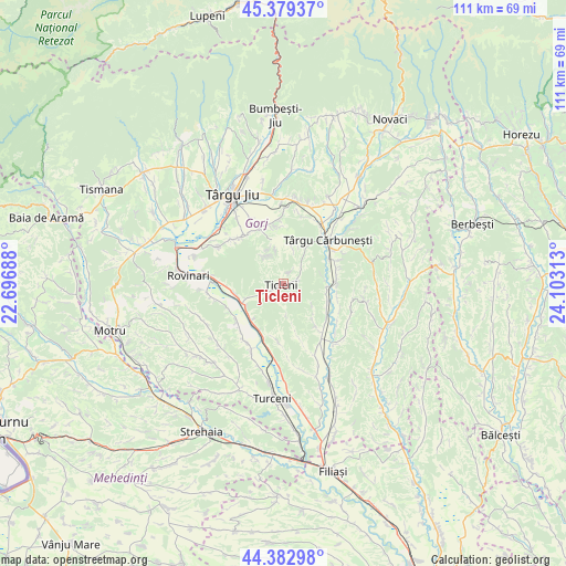
Ţicleni GPS coordinates[2]
44° 52' 59.988" North, 23° 24' 0" East
| Map corner | latitude | longitude |
|---|---|---|
| Upper-left | 45.37937°, | 22.69688° |
| Center: | 44.88333°, | 23.4° |
| Lower-right: | 44.38298°, | 24.10313° |
| Map W x H: | 110.8×110.8 km | = 68.8×68.8mi |
| max Lat: | 48.23793° ⇑73.7% North |
| Ţicleni: | 44.88333° |
| min Lat: | ⇓26.3% South 43.65638° |
| min Long | Ţicleni | max Long |
| 20.31667° | 23.4° | 29.65403° |
| W 21.4%⇐ | ⇒78.6% E |
Elevation
Elevation of Ţicleni is 179 m = 587 ft, and this is 75.9 m = 249 ft below average elevation for this country.
| Max E: |
1278 m = 4193 ft | 56.8% |
| Avg. | 254.9 m = 836 ft | |
| Ţicleni | 179 m = 587 ft | |
Min E: |
-2 m = -7 ft | 43.2% |
See also: Romania elevation on elevation.city.
Geographical zone
Ţicleni is located in North temperate zone (between Tropic of Cancer and the Arctic Circle). Distance of this Northern Tropic circle is 2384.6 km =1481.7 mi to South.| Distance of | km | miles | from Ţicleni |
|---|---|---|---|
| North Pole | 5016.5 | 3117.1 | to North |
| Arctic Circle | 2410.6 | 1497.9 | to North |
| Tropic Cancer | 2384.6 | 1481.7 | to South |
| Equator | 4990.6 | 3101 | to South |


Nearby cities:
15 places around Ţicleni: (largest is in red/bold)
• Bâlteni
10.1 km =6.3 mi,  261°
261°
• Bărbăteşti
8.1 km =5 mi,  103°
103°
• Cocoreni
9.2 km =5.7 mi,  227°
227°
• Dăneşti
10.6 km =6.6 mi,  330°
330°
• Hotăroasa
11.4 km =7.1 mi, 234°
• Jupâneşti
10.7 km =6.6 mi,  79°
79°
• Olari
10 km =6.2 mi,  212°
212°
• Petrești
9.4 km =5.8 mi,  113°
113°
• Peșteana Jiu
8.6 km =5.3 mi,  241°
241°
• Peșteana de Jos
11.7 km =7.3 mi, 241°
• Plopşoru
11.8 km =7.3 mi,  199°
199°
• Sterpoaia
10.7 km =6.6 mi,  164°
164°
• Săuleşti
11.4 km =7.1 mi,  144°
144°
• Târgu Cărbuneşti
11.8 km =7.3 mi,  51°
51°
• Vierșani
10.3 km =6.4 mi,  92°
92°
Sources, notices
• [Note1] Compared only with cities in Romania existing in our database
• [Src1] Map data: © OpenStreetMap contributors (CC-BY-SA)
• [Src2] Other city data from geonames.org with taken over terms of usage.
• [Src3] Geographical zone / Annual Mean Temperature by Robert A. Rohde @ Wikipedia
