Plopşoru geodata
Plopşoru (Gorj) is a seat of a second-order administrative division; located in Romania in Europe/Bucharest (GMT+3) time zone. With population of 6,576 people, there are 459 cities with bigger population in this country. Compared to other cities in Romania, 77.4% of cities are located further ↑North; 79.3% of cities are located further →East and 66.5% of cities have higher elevation than Plopşoru. Note1


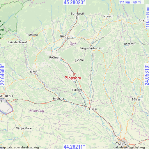
Plopşoru GPS coordinates[2]
44° 46' 59.988" North, 23° 21' 0" East
| Map corner | latitude | longitude |
|---|---|---|
| Upper-left | 45.28023°, | 22.64688° |
| Center: | 44.78333°, | 23.35° |
| Lower-right: | 44.28211°, | 24.05313° |
| Map W x H: | 111×111 km | = 69×69mi |
| max Lat: | 48.23793° ⇑77.4% North |
| Plopşoru: | 44.78333° |
| min Lat: | ⇓22.6% South 43.65638° |
| min Long | Plopşoru | max Long |
| 20.31667° | 23.35° | 29.65403° |
| W 20.7%⇐ | ⇒79.3% E |
Elevation
Elevation of Plopşoru is 141 m = 463 ft, and this is 113.9 m = 374 ft below average elevation for this country.
| Max E: |
1278 m = 4193 ft | 66.5% |
| Avg. | 254.9 m = 836 ft | |
| Plopşoru | 141 m = 463 ft | |
Min E: |
-2 m = -7 ft | 33.5% |
See also: Romania elevation on elevation.city.
Geographical zone
Plopşoru is located in North temperate zone (between Tropic of Cancer and the Arctic Circle). Distance of this Northern Tropic circle is 2373.5 km =1474.8 mi to South.| Distance of | km | miles | from Plopşoru |
|---|---|---|---|
| North Pole | 5027.6 | 3124 | to North |
| Arctic Circle | 2421.7 | 1504.8 | to North |
| Tropic Cancer | 2373.5 | 1474.8 | to South |
| Equator | 4979.4 | 3094.1 | to South |


Nearby cities:
15 places around Plopşoru: (largest is in red/bold)
• Cocoreni
5.7 km =3.5 mi,  330°
330°
• Costești
9.4 km =5.8 mi,  126°
126°
• Fântânele
3.1 km =1.9 mi,  259°
259°
• Hotăroasa
6.9 km =4.3 mi,  309°
309°
• Izvoarele
8.3 km =5.2 mi,  152°
152°
• Murgești
8.1 km =5 mi,  172°
172°
• Olari
3 km =1.9 mi, 332°
• Peșteana Jiu
7.9 km =4.9 mi, 332°
• Peșteana de Jos
8.4 km =5.2 mi, 311°
• Piscuri
3.5 km =2.2 mi,  102°
102°
• Sterpoaia
6.8 km =4.2 mi,  83°
83°
• Sărdănești
1.6 km =1 mi, 148°
• Urdari
4.4 km =2.7 mi,  295°
295°
• Valea Viei
4.9 km =3 mi,  194°
194°
• Văleni
5.5 km =3.4 mi, 148°
Sources, notices
• [Note1] Compared only with cities in Romania existing in our database
• [Src1] Map data: © OpenStreetMap contributors (CC-BY-SA)
• [Src2] Other city data from geonames.org with taken over terms of usage.
• [Src3] Geographical zone / Annual Mean Temperature by Robert A. Rohde @ Wikipedia
