Surani geodata
Surani (Prahova) is a seat of a second-order administrative division; located in Romania in Europe/Bucharest (GMT+3) time zone. With population of 1,838 people, there are 2779 cities with bigger population in this country. Compared to other cities in Romania, 61.7% of cities are located further ↑North; 66.3% of cities are located further ←West and 76.2% of cities have lower elevation than Surani. Note1


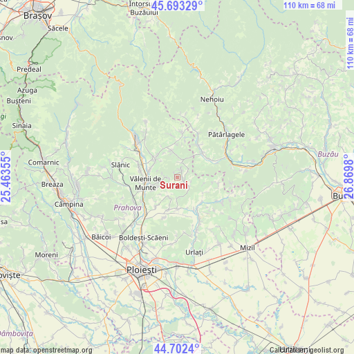
Surani GPS coordinates[2]
45° 12' 0" North, 26° 10' 0.012" East
| Map corner | latitude | longitude |
|---|---|---|
| Upper-left | 45.69329°, | 25.46355° |
| Center: | 45.2°, | 26.16667° |
| Lower-right: | 44.7024°, | 26.8698° |
| Map W x H: | 110.2×110.2 km | = 68.5×68.5mi |
| max Lat: | 48.23793° ⇑61.7% North |
| Surani: | 45.2° |
| min Lat: | ⇓38.3% South 43.65638° |
| min Long | Surani | max Long |
| 20.31667° | 26.16667° | 29.65403° |
| W 66.3%⇐ | ⇒33.7% E |
Elevation
Elevation of Surani is 362 m = 1188 ft, and this is 107.1 m = 351 ft above average elevation for this country.
| Max E: |
1278 m = 4193 ft | 23.8% |
| Surani | 362 m 1188 ft | |
| Avg. | 254.9 m = 836 ft | |
Min E: |
-2 m = -7 ft | 76.2% |
See also: Romania elevation on elevation.city.
Geographical zone
Surani is located in North temperate zone (between Tropic of Cancer and the Arctic Circle). Distance of this North polar circle is 2375.4 km =1476 mi to North.| Distance of | km | miles | from Surani |
|---|---|---|---|
| North Pole | 4981.3 | 3095.2 | to North |
| Arctic Circle | 2375.4 | 1476 | to North |
| Tropic Cancer | 2419.8 | 1503.6 | to South |
| Equator | 5025.8 | 3122.9 | to South |


Nearby cities:
15 places around Surani: (largest is in red/bold)
• Ariceștii Zeletin
2.7 km =1.7 mi,  22°
22°
• Chiojdeanca
8.7 km =5.4 mi,  115°
115°
• Cărbuneşti
4.5 km =2.8 mi,  35°
35°
• Lopatnița
4.5 km =2.8 mi,  110°
110°
• Matița
6.5 km =4 mi,  181°
181°
• Măgura
6.1 km =3.8 mi,  154°
154°
• Podenii Noi
9.3 km =5.8 mi, 180°
• Poiana Copăceni
8.6 km =5.3 mi,  242°
242°
• Poseștii-Pământeni
7.5 km =4.7 mi,  350°
350°
• Predeal
5.2 km =3.2 mi,  254°
254°
• Păcureţi
6.1 km =3.8 mi,  205°
205°
• Trenu
8.2 km =5.1 mi,  101°
101°
• Târlești
6.8 km =4.2 mi, 35°
• Vitioara de Sus
8.2 km =5.1 mi, 254°
• Şoimari
3.2 km =2 mi,  125°
125°
Sources, notices
• [Note1] Compared only with cities in Romania existing in our database
• [Src1] Map data: © OpenStreetMap contributors (CC-BY-SA)
• [Src2] Other city data from geonames.org with taken over terms of usage.
• [Src3] Geographical zone / Annual Mean Temperature by Robert A. Rohde @ Wikipedia
