Măgura geodata
Măgura (Prahova) is a populated place; located in Romania in Europe/Bucharest (GMT+3) time zone. With population of 532 people, there are 6760 cities with bigger population in this country. Compared to other cities in Romania, 63.6% of cities are located further ↑North; 66.8% of cities are located further ←West and 61.7% of cities have lower elevation than Măgura. Note1


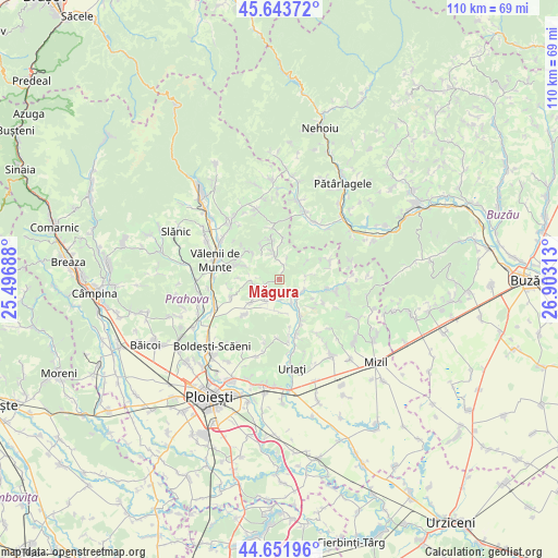
Măgura GPS coordinates[2]
45° 9' 0" North, 26° 12' 0" East
| Map corner | latitude | longitude |
|---|---|---|
| Upper-left | 45.64372°, | 25.49688° |
| Center: | 45.15°, | 26.2° |
| Lower-right: | 44.65196°, | 26.90313° |
| Map W x H: | 110.3×110.3 km | = 68.5×68.5mi |
| max Lat: | 48.23793° ⇑63.6% North |
| Măgura: | 45.15° |
| min Lat: | ⇓36.4% South 43.65638° |
| min Long | Măgura | max Long |
| 20.31667° | 26.2° | 29.65403° |
| W 66.8%⇐ | ⇒33.2% E |
Elevation
Elevation of Măgura is 273 m = 896 ft, and this is 18.1 m = 59 ft above average elevation for this country.
| Max E: |
1278 m = 4193 ft | 38.3% |
| Măgura | 273 m 896 ft | |
| Avg. | 254.9 m = 836 ft | |
Min E: |
-2 m = -7 ft | 61.7% |
See also: Romania elevation on elevation.city.
Geographical zone
Măgura is located in North temperate zone (between Tropic of Cancer and the Arctic Circle). Distance of this North polar circle is 2381 km =1479.5 mi to North.| Distance of | km | miles | from Măgura |
|---|---|---|---|
| North Pole | 4986.9 | 3098.7 | to North |
| Arctic Circle | 2381 | 1479.5 | to North |
| Tropic Cancer | 2414.3 | 1500.2 | to South |
| Equator | 5020.2 | 3119.4 | to South |


Nearby cities:
15 places around Măgura: (largest is in red/bold)
• Apostolache
5.5 km =3.4 mi,  109°
109°
• Ariceștii Zeletin
8.2 km =5.1 mi,  348°
348°
• Bălțești
7.1 km =4.4 mi,  231°
231°
• Chiojdeanca
5.5 km =3.4 mi,  70°
70°
• Coșerele
8.2 km =5.1 mi,  147°
147°
• Lopatnița
4.3 km =2.7 mi,  21°
21°
• Matița
3 km =1.9 mi,  252°
252°
• Nucet
6.9 km =4.3 mi,  81°
81°
• Podenii Noi
4.5 km =2.8 mi,  215°
215°
• Popești
5.5 km =3.4 mi, 151°
• Păcureţi
5.2 km =3.2 mi,  270°
270°
• Surani
6.1 km =3.8 mi,  334°
334°
• Trenu
6.7 km =4.2 mi,  54°
54°
• Valea Dulce
4 km =2.5 mi,  171°
171°
• Şoimari
3.7 km =2.3 mi,  0°
0°
Sources, notices
• [Note1] Compared only with cities in Romania existing in our database
• [Src1] Map data: © OpenStreetMap contributors (CC-BY-SA)
• [Src2] Other city data from geonames.org with taken over terms of usage.
• [Src3] Geographical zone / Annual Mean Temperature by Robert A. Rohde @ Wikipedia
