Lopatnița geodata
Lopatnița (Prahova) is a populated place; located in Romania in Europe/Bucharest (GMT+3) time zone. With population of 757 people, there are 5254 cities with bigger population in this country. Compared to other cities in Romania, 62% of cities are located further ↑North; 67.3% of cities are located further ←West and 55.8% of cities have lower elevation than Lopatnița. Note1


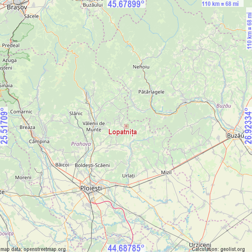
Lopatnița GPS coordinates[2]
45° 11' 8.088" North, 26° 13' 12.756" East
| Map corner | latitude | longitude |
|---|---|---|
| Upper-left | 45.67899°, | 25.51709° |
| Center: | 45.18558°, | 26.22021° |
| Lower-right: | 44.68785°, | 26.92334° |
| Map W x H: | 110.2×110.2 km | = 68.5×68.5mi |
| max Lat: | 48.23793° ⇑62% North |
| Lopatnița: | 45.18558° |
| min Lat: | ⇓38% South 43.65638° |
| min Long | Lopatnița | max Long |
| 20.31667° | 26.22021° | 29.65403° |
| W 67.3%⇐ | ⇒32.7% E |
Elevation
Elevation of Lopatnița is 242 m = 794 ft, and this is 12.9 m = 42 ft below average elevation for this country.
| Max E: |
1278 m = 4193 ft | 44.2% |
| Avg. | 254.9 m = 836 ft | |
| Lopatnița | 242 m = 794 ft | |
Min E: |
-2 m = -7 ft | 55.8% |
See also: Romania elevation on elevation.city.
Geographical zone
Lopatnița is located in North temperate zone (between Tropic of Cancer and the Arctic Circle). Distance of this North polar circle is 2377 km =1477 mi to North.| Distance of | km | miles | from Lopatnița |
|---|---|---|---|
| North Pole | 4982.9 | 3096.2 | to North |
| Arctic Circle | 2377 | 1477 | to North |
| Tropic Cancer | 2418.2 | 1502.6 | to South |
| Equator | 5024.2 | 3121.9 | to South |


Nearby cities:
15 places around Lopatnița: (largest is in red/bold)
• Apostolache
6.9 km =4.3 mi,  147°
147°
• Ariceștii Zeletin
5.2 km =3.2 mi,  321°
321°
• Chiojdeanca
4.2 km =2.6 mi,  120°
120°
• Cărbuneşti
5.5 km =3.4 mi,  343°
343°
• Matița
6.6 km =4.1 mi,  222°
222°
• Măgura
4.3 km =2.7 mi,  201°
201°
• Nucet
6.1 km =3.8 mi, 119°
• Podenii Noi
8.7 km =5.4 mi,  208°
208°
• Popești
8.8 km =5.5 mi,  173°
173°
• Păcureţi
7.9 km =4.9 mi,  239°
239°
• Surani
4.5 km =2.8 mi,  290°
290°
• Trenu
3.9 km =2.4 mi,  90°
90°
• Târlești
7.2 km =4.5 mi,  357°
357°
• Valea Dulce
8 km =5 mi,  186°
186°
• Şoimari
1.6 km =1 mi,  261°
261°
Sources, notices
• [Note1] Compared only with cities in Romania existing in our database
• [Src1] Map data: © OpenStreetMap contributors (CC-BY-SA)
• [Src2] Other city data from geonames.org with taken over terms of usage.
• [Src3] Geographical zone / Annual Mean Temperature by Robert A. Rohde @ Wikipedia
