Sultana geodata
Sultana (Călăraşi) is a populated place; located in Romania in Europe/Bucharest (GMT+3) time zone. With population of 1,137 people, there are 3884 cities with bigger population in this country. Compared to other cities in Romania, 91.8% of cities are located further ↑North; 79.9% of cities are located further ←West and 92.6% of cities have higher elevation than Sultana. Note1


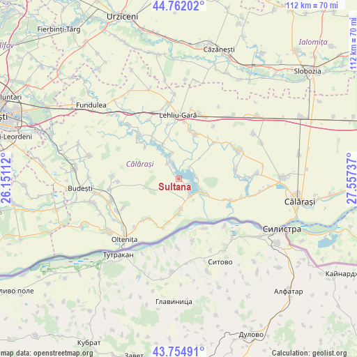
Sultana GPS coordinates[2]
44° 15' 38.232" North, 26° 51' 15.264" East
| Map corner | latitude | longitude |
|---|---|---|
| Upper-left | 44.76202°, | 26.15112° |
| Center: | 44.26062°, | 26.85424° |
| Lower-right: | 43.75491°, | 27.55737° |
| Map W x H: | 112×112 km | = 69.6×69.6mi |
| max Lat: | 48.23793° ⇑91.8% North |
| Sultana: | 44.26062° |
| min Lat: | ⇓8.2% South 43.65638° |
| min Long | Sultana | max Long |
| 20.31667° | 26.85424° | 29.65403° |
| W 79.9%⇐ | ⇒20.1% E |
Elevation
Elevation of Sultana is 46 m = 151 ft, and this is 208.9 m = 685 ft below average elevation for this country.
| Max E: |
1278 m = 4193 ft | 92.6% |
| Avg. | 254.9 m = 836 ft | |
| Sultana | 46 m = 151 ft | |
Min E: |
-2 m = -7 ft | 7.4% |
See also: Romania elevation on elevation.city.
Geographical zone
Sultana is located in North temperate zone (between Tropic of Cancer and the Arctic Circle). Distance of this Northern Tropic circle is 2315.4 km =1438.7 mi to South.| Distance of | km | miles | from Sultana |
|---|---|---|---|
| North Pole | 5085.7 | 3160.1 | to North |
| Arctic Circle | 2479.9 | 1540.9 | to North |
| Tropic Cancer | 2315.4 | 1438.7 | to South |
| Equator | 4921.3 | 3058 | to South |


Nearby cities:
15 places around Sultana: (largest is in red/bold)
• Boșneagu
6.8 km =4.2 mi,  111°
111°
• Chiselet
8.6 km =5.3 mi,  182°
182°
• Coconi
2.8 km =1.7 mi,  121°
121°
• Dorobanţu
9.1 km =5.7 mi, 122°
• Frăsinet
7.6 km =4.7 mi,  325°
325°
• Făurei
5 km =3.1 mi,  43°
43°
• Luptători
5.9 km =3.7 mi,  324°
324°
• Lupşanu
14.1 km =8.8 mi,  14°
14°
• Mânăstirea
6.1 km =3.8 mi,  143°
143°
• Radu Vodă
15 km =9.3 mi,  22°
22°
• Siliștea
13.9 km =8.6 mi, 326°
• Stancea
14.2 km =8.8 mi,  193°
193°
• Ulmu
5 km =3.1 mi,  82°
82°
• Valea Argovei
11.4 km =7.1 mi, 330°
• Vărăști
10.8 km =6.7 mi, 119°
Sources, notices
• [Note1] Compared only with cities in Romania existing in our database
• [Src1] Map data: © OpenStreetMap contributors (CC-BY-SA)
• [Src2] Other city data from geonames.org with taken over terms of usage.
• [Src3] Geographical zone / Annual Mean Temperature by Robert A. Rohde @ Wikipedia
