Mânăstirea geodata
Mânăstirea (Călăraşi) is a seat of a second-order administrative division; located in Romania in Europe/Bucharest (GMT+3) time zone. With population of 6,123 people, there are 527 cities with bigger population in this country. Compared to other cities in Romania, 93% of cities are located further ↑North; 80.9% of cities are located further ←West and 98.1% of cities have higher elevation than Mânăstirea. Note1


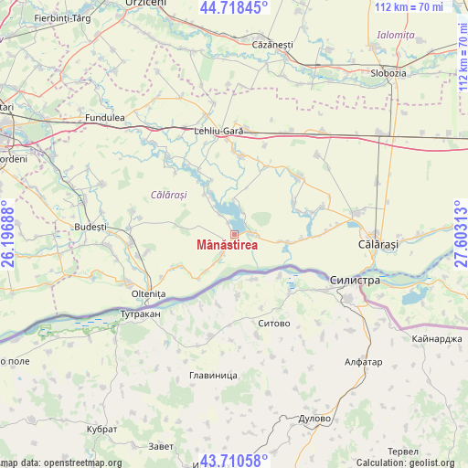
Mânăstirea GPS coordinates[2]
44° 13' 0.012" North, 26° 54' 0" East
| Map corner | latitude | longitude |
|---|---|---|
| Upper-left | 44.71845°, | 26.19688° |
| Center: | 44.21667°, | 26.9° |
| Lower-right: | 43.71058°, | 27.60313° |
| Map W x H: | 112.1×112.1 km | = 69.7×69.7mi |
| max Lat: | 48.23793° ⇑93% North |
| Mânăstirea: | 44.21667° |
| min Lat: | ⇓7% South 43.65638° |
| min Long | Mânăstirea | max Long |
| 20.31667° | 26.9° | 29.65403° |
| W 80.9%⇐ | ⇒19.1% E |
Elevation
Elevation of Mânăstirea is 17 m = 56 ft, and this is 237.9 m = 781 ft below average elevation for this country.
| Max E: |
1278 m = 4193 ft | 98.1% |
| Avg. | 254.9 m = 836 ft | |
| Mânăstirea | 17 m = 56 ft | |
Min E: |
-2 m = -7 ft | 1.9% |
See also: Romania elevation on elevation.city.
Geographical zone
Mânăstirea is located in North temperate zone (between Tropic of Cancer and the Arctic Circle). Distance of this Northern Tropic circle is 2310.5 km =1435.7 mi to South.| Distance of | km | miles | from Mânăstirea |
|---|---|---|---|
| North Pole | 5090.6 | 3163.2 | to North |
| Arctic Circle | 2484.7 | 1543.9 | to North |
| Tropic Cancer | 2310.5 | 1435.7 | to South |
| Equator | 4916.4 | 3054.9 | to South |


Nearby cities:
15 places around Mânăstirea: (largest is in red/bold)
• Alexandru Odobescu
15.6 km =9.7 mi,  69°
69°
• Boșneagu
3.6 km =2.2 mi,  47°
47°
• Cetatea Veche
14.1 km =8.8 mi,  229°
229°
• Chiselet
5.4 km =3.4 mi, 227°
• Ciocăneşti
13.4 km =8.3 mi,  97°
97°
• Coconi
3.7 km =2.3 mi,  339°
339°
• Dorobanţu
4 km =2.5 mi,  90°
90°
• Frăsinet
13.7 km =8.5 mi,  324°
324°
• Făurei
8.5 km =5.3 mi,  358°
358°
• Luptători
12 km =7.5 mi, 323°
• Spanţov
14.5 km =9 mi,  219°
219°
• Stancea
11.3 km =7 mi, 218°
• Sultana
6.1 km =3.8 mi, 323°
• Ulmu
5.7 km =3.5 mi,  13°
13°
• Vărăști
5.7 km =3.5 mi, 94°
Sources, notices
• [Note1] Compared only with cities in Romania existing in our database
• [Src1] Map data: © OpenStreetMap contributors (CC-BY-SA)
• [Src2] Other city data from geonames.org with taken over terms of usage.
• [Src3] Geographical zone / Annual Mean Temperature by Robert A. Rohde @ Wikipedia
