Știnăpari geodata
Știnăpari (Caraş-Severin) is a populated place; located in Romania in Europe/Bucharest (GMT+3) time zone. With population of 519 people, there are 6870 cities with bigger population in this country. Compared to other cities in Romania, 75% of cities are located further ↑North; 96.2% of cities are located further →East and 94.2% of cities have lower elevation than Știnăpari. Note1


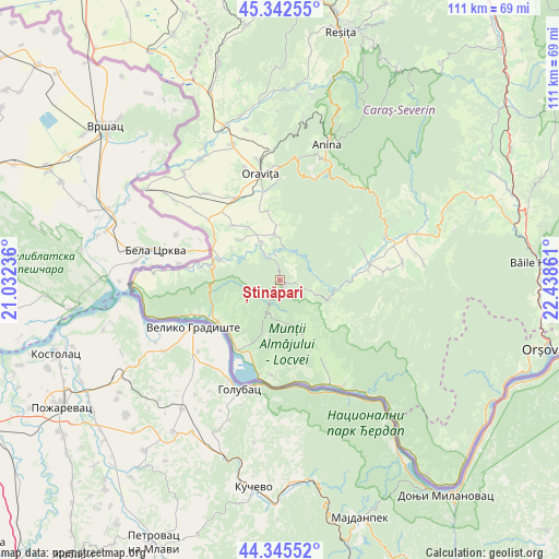
Știnăpari GPS coordinates[2]
44° 50' 46.284" North, 21° 44' 7.728" East
| Map corner | latitude | longitude |
|---|---|---|
| Upper-left | 45.34255°, | 21.03236° |
| Center: | 44.84619°, | 21.73548° |
| Lower-right: | 44.34552°, | 22.43861° |
| Map W x H: | 110.9×110.9 km | = 68.9×68.9mi |
| max Lat: | 48.23793° ⇑75% North |
| Știnăpari: | 44.84619° |
| min Lat: | ⇓25% South 43.65638° |
| min Long | Știnăpari | max Long |
| 20.31667° | 21.73548° | 29.65403° |
| W 3.8%⇐ | ⇒96.2% E |
Elevation
Elevation of Știnăpari is 601 m = 1972 ft, and this is 346.1 m = 1135 ft above average elevation for this country.
| Max E: |
1278 m = 4193 ft | 5.8% |
| Știnăpari | 601 m 1972 ft | |
| Avg. | 254.9 m = 836 ft | |
Min E: |
-2 m = -7 ft | 94.2% |
See also: Romania elevation on elevation.city.
Geographical zone
Știnăpari is located in North temperate zone (between Tropic of Cancer and the Arctic Circle). Distance of this Northern Tropic circle is 2380.5 km =1479.2 mi to South.| Distance of | km | miles | from Știnăpari |
|---|---|---|---|
| North Pole | 5020.6 | 3119.7 | to North |
| Arctic Circle | 2414.7 | 1500.4 | to North |
| Tropic Cancer | 2380.5 | 1479.2 | to South |
| Equator | 4986.4 | 3098.4 | to South |


Nearby cities:
15 places around Știnăpari: (largest is in red/bold)
• Ciuchici
14.5 km =9 mi,  316°
316°
• Cărbunari
1.5 km =0.9 mi,  152°
152°
• Gârnic
8.1 km =5 mi, 145°
• Moceriș
15 km =9.3 mi,  79°
79°
• Moldova Nouă
13.2 km =8.2 mi,  204°
204°
• Măcești
14.2 km =8.8 mi,  224°
224°
• Naidăș
12.1 km =7.5 mi,  288°
288°
• Padina Matei
9.8 km =6.1 mi,  172°
172°
• Pojejena
14.7 km =9.1 mi,  236°
236°
• Radimna
14.7 km =9.1 mi,  247°
247°
• Sasca Montană
4.8 km =3 mi,  334°
334°
• Sasca Română
5.2 km =3.2 mi,  350°
350°
• Sicheviţa
15.2 km =9.4 mi,  144°
144°
• Şopotu Nou
10 km =6.2 mi,  92°
92°
• Șușca
17.5 km =10.9 mi, 246°
Sources, notices
• [Note1] Compared only with cities in Romania existing in our database
• [Src1] Map data: © OpenStreetMap contributors (CC-BY-SA)
• [Src2] Other city data from geonames.org with taken over terms of usage.
• [Src3] Geographical zone / Annual Mean Temperature by Robert A. Rohde @ Wikipedia
