Sopot geodata
Sopot (Dolj) is a seat of a second-order administrative division; located in Romania in Europe/Bucharest (GMT+3) time zone. With population of 472 people, there are 7023 cities with bigger population in this country. Compared to other cities in Romania, 87.8% of cities are located further ↑North; 77% of cities are located further →East and 54.1% of cities have higher elevation than Sopot. Note1


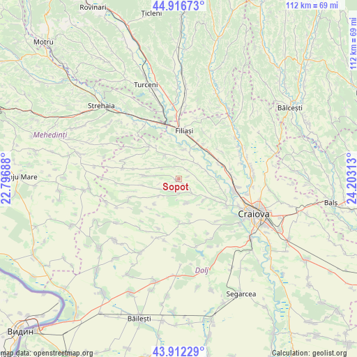
Sopot GPS coordinates[2]
44° 25' 0.012" North, 23° 30' 0" East
| Map corner | latitude | longitude |
|---|---|---|
| Upper-left | 44.91673°, | 22.79688° |
| Center: | 44.41667°, | 23.5° |
| Lower-right: | 43.91229°, | 24.20313° |
| Map W x H: | 111.7×111.7 km | = 69.4×69.4mi |
| max Lat: | 48.23793° ⇑87.8% North |
| Sopot: | 44.41667° |
| min Lat: | ⇓12.2% South 43.65638° |
| min Long | Sopot | max Long |
| 20.31667° | 23.5° | 29.65403° |
| W 23%⇐ | ⇒77% E |
Elevation
Elevation of Sopot is 191 m = 627 ft, and this is 63.9 m = 210 ft below average elevation for this country.
| Max E: |
1278 m = 4193 ft | 54.1% |
| Avg. | 254.9 m = 836 ft | |
| Sopot | 191 m = 627 ft | |
Min E: |
-2 m = -7 ft | 45.9% |
See also: Romania elevation on elevation.city.
Geographical zone
Sopot is located in North temperate zone (between Tropic of Cancer and the Arctic Circle). Distance of this Northern Tropic circle is 2332.8 km =1449.5 mi to South.| Distance of | km | miles | from Sopot |
|---|---|---|---|
| North Pole | 5068.4 | 3149.4 | to North |
| Arctic Circle | 2462.5 | 1530.1 | to North |
| Tropic Cancer | 2332.8 | 1449.5 | to South |
| Equator | 4938.7 | 3068.8 | to South |


Nearby cities:
15 places around Sopot: (largest is in red/bold)
• Brabova
7.7 km =4.8 mi,  223°
223°
• Braloştiţa
9.4 km =5.8 mi,  8°
8°
• Cernăteşti
6.5 km =4 mi,  304°
304°
• Coţofenii din Dos
9.4 km =5.8 mi,  78°
78°
• Gogoşu
10.6 km =6.6 mi,  270°
270°
• Pleșoi
7.8 km =4.8 mi,  160°
160°
• Predeşti
10.9 km =6.8 mi,  133°
133°
• Rasnicu Oghian
3.8 km =2.4 mi,  40°
40°
• Salcia
8.4 km =5.2 mi,  329°
329°
• Scăeşti
8.6 km =5.3 mi,  49°
49°
• Sfârcea
8.6 km =5.3 mi,  25°
25°
• Urdinița
6.6 km =4.1 mi,  242°
242°
• Valea Fântânilor
9.5 km =5.9 mi,  352°
352°
• Valea lui Pătru
6.4 km =4 mi,  15°
15°
• Țiu
9.9 km =6.2 mi,  289°
289°
Sources, notices
• [Note1] Compared only with cities in Romania existing in our database
• [Src1] Map data: © OpenStreetMap contributors (CC-BY-SA)
• [Src2] Other city data from geonames.org with taken over terms of usage.
• [Src3] Geographical zone / Annual Mean Temperature by Robert A. Rohde @ Wikipedia
