Solonţ geodata
Solonţ (Bacău) is a seat of a second-order administrative division; located in Romania in Europe/Bucharest (GMT+3) time zone. With population of 3,866 people, there are 1218 cities with bigger population in this country. Compared to other cities in Romania, 68.1% of cities are located further ↓South; 72.9% of cities are located further ←West and 93.8% of cities have lower elevation than Solonţ. Note1


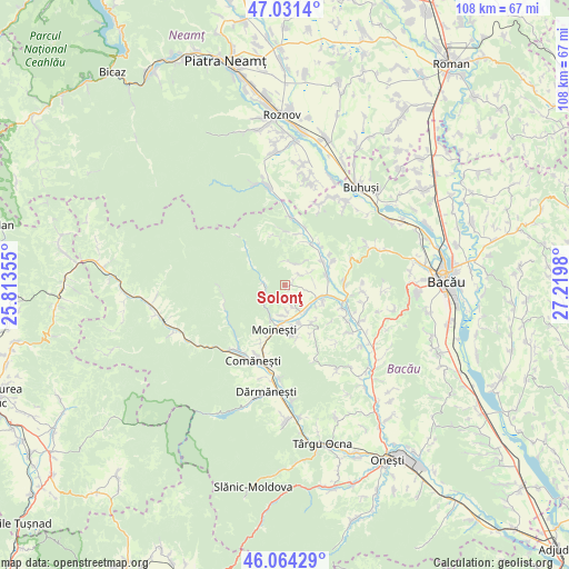
Solonţ GPS coordinates[2]
46° 33' 0" North, 26° 31' 0.012" East
| Map corner | latitude | longitude |
|---|---|---|
| Upper-left | 47.0314°, | 25.81355° |
| Center: | 46.55°, | 26.51667° |
| Lower-right: | 46.06429°, | 27.2198° |
| Map W x H: | 107.5×107.5 km | = 66.8×66.8mi |
| max Lat: | 48.23793° ⇑31.9% North |
| Solonţ: | 46.55° |
| min Lat: | ⇓68.1% South 43.65638° |
| min Long | Solonţ | max Long |
| 20.31667° | 26.51667° | 29.65403° |
| W 72.9%⇐ | ⇒27.1% E |
Elevation
Elevation of Solonţ is 588 m = 1929 ft, and this is 333.1 m = 1093 ft above average elevation for this country.
| Max E: |
1278 m = 4193 ft | 6.2% |
| Solonţ | 588 m 1929 ft | |
| Avg. | 254.9 m = 836 ft | |
Min E: |
-2 m = -7 ft | 93.8% |
See also: Romania elevation on elevation.city.
Geographical zone
Solonţ is located in North temperate zone (between Tropic of Cancer and the Arctic Circle). Distance of this North polar circle is 2225.3 km =1382.7 mi to North.| Distance of | km | miles | from Solonţ |
|---|---|---|---|
| North Pole | 4831.2 | 3002 | to North |
| Arctic Circle | 2225.3 | 1382.7 | to North |
| Tropic Cancer | 2570 | 1596.9 | to South |
| Equator | 5175.9 | 3216.2 | to South |


Nearby cities:
15 places around Solonţ: (largest is in red/bold)
• Ardeoani
6.6 km =4.1 mi,  106°
106°
• Bucșești
8.9 km =5.5 mi,  145°
145°
• Băhnășeni
5.6 km =3.5 mi,  63°
63°
• Cucuieți
4.5 km =2.8 mi,  11°
11°
• Găzărie
6.8 km =4.2 mi,  178°
178°
• Leontinești
6.9 km =4.3 mi,  122°
122°
• Moineşti
8.6 km =5.3 mi,  194°
194°
• Măgireşti
4.5 km =2.8 mi, 145°
• Prohozești
8.1 km =5 mi,  160°
160°
• Prăjești
5 km =3.1 mi,  171°
171°
• Pârjol
7.4 km =4.6 mi, 59°
• Stănești
2.9 km =1.8 mi, 153°
• Sărata
3.3 km =2.1 mi, 55°
• Valea Arinilor
5.8 km =3.6 mi, 185°
• Zemeş
8.5 km =5.3 mi,  295°
295°
Sources, notices
• [Note1] Compared only with cities in Romania existing in our database
• [Src1] Map data: © OpenStreetMap contributors (CC-BY-SA)
• [Src2] Other city data from geonames.org with taken over terms of usage.
• [Src3] Geographical zone / Annual Mean Temperature by Robert A. Rohde @ Wikipedia
