Smeeni geodata
Smeeni (Buzău) is a seat of a second-order administrative division; located in Romania in Europe/Bucharest (GMT+3) time zone. With population of 7,015 people, there are 409 cities with bigger population in this country. Compared to other cities in Romania, 70.3% of cities are located further ↑North; 79.7% of cities are located further ←West and 85.1% of cities have higher elevation than Smeeni. Note1


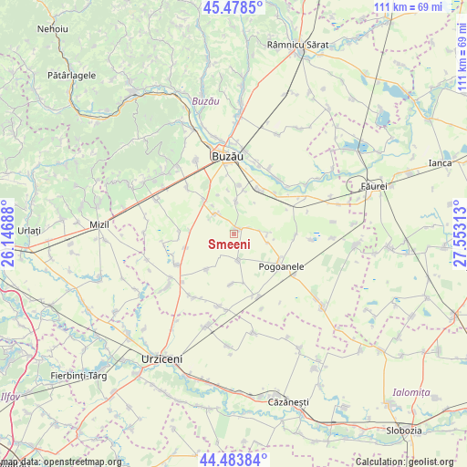
Smeeni GPS coordinates[2]
44° 58' 59.988" North, 26° 51' 0" East
| Map corner | latitude | longitude |
|---|---|---|
| Upper-left | 45.4785°, | 26.14688° |
| Center: | 44.98333°, | 26.85° |
| Lower-right: | 44.48384°, | 27.55313° |
| Map W x H: | 110.6×110.6 km | = 68.7×68.7mi |
| max Lat: | 48.23793° ⇑70.3% North |
| Smeeni: | 44.98333° |
| min Lat: | ⇓29.7% South 43.65638° |
| min Long | Smeeni | max Long |
| 20.31667° | 26.85° | 29.65403° |
| W 79.7%⇐ | ⇒20.3% E |
Elevation
Elevation of Smeeni is 78 m = 256 ft, and this is 176.9 m = 580 ft below average elevation for this country.
| Max E: |
1278 m = 4193 ft | 85.1% |
| Avg. | 254.9 m = 836 ft | |
| Smeeni | 78 m = 256 ft | |
Min E: |
-2 m = -7 ft | 14.9% |
See also: Romania elevation on elevation.city.
Geographical zone
Smeeni is located in North temperate zone (between Tropic of Cancer and the Arctic Circle). Distance of this Northern Tropic circle is 2395.8 km =1488.7 mi to South.| Distance of | km | miles | from Smeeni |
|---|---|---|---|
| North Pole | 5005.4 | 3110.2 | to North |
| Arctic Circle | 2399.5 | 1491 | to North |
| Tropic Cancer | 2395.8 | 1488.7 | to South |
| Equator | 5001.7 | 3107.9 | to South |


Nearby cities:
15 places around Smeeni: (largest is in red/bold)
• Albești
6 km =3.7 mi,  82°
82°
• Brădeanu
5.6 km =3.5 mi,  180°
180°
• Budișteni
8.4 km =5.2 mi,  322°
322°
• Costeşti
9.9 km =6.2 mi, 318°
• Călțuna
8.2 km =5.1 mi,  105°
105°
• Florica
10.7 km =6.6 mi,  218°
218°
• Gherăseni
6.6 km =4.1 mi, 315°
• Limpeziș
11.9 km =7.4 mi,  253°
253°
• Maxenu
7.6 km =4.7 mi,  2°
2°
• Mitropolia
11.9 km =7.4 mi,  168°
168°
• Pietrosu
11.1 km =6.9 mi, 319°
• Pogonele
11.5 km =7.1 mi,  5°
5°
• Smârdan
11.2 km =7 mi,  186°
186°
• Sudiți
5.4 km =3.4 mi, 324°
• Ţinteşti
9.4 km =5.8 mi, 8°
Sources, notices
• [Note1] Compared only with cities in Romania existing in our database
• [Src1] Map data: © OpenStreetMap contributors (CC-BY-SA)
• [Src2] Other city data from geonames.org with taken over terms of usage.
• [Src3] Geographical zone / Annual Mean Temperature by Robert A. Rohde @ Wikipedia
