Slobozia geodata
Slobozia (Bacău) is a populated place; located in Romania in Europe/Bucharest (GMT+3) time zone. With population of 788 people, there are 5107 cities with bigger population in this country. Compared to other cities in Romania, 61.5% of cities are located further ↓South; 78.6% of cities are located further ←West and 52.7% of cities have higher elevation than Slobozia. Note1


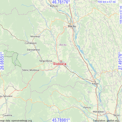
Slobozia GPS coordinates[2]
46° 16' 40.584" North, 26° 47' 19.068" East
| Map corner | latitude | longitude |
|---|---|---|
| Upper-left | 46.76176°, | 26.08551° |
| Center: | 46.27794°, | 26.78863° |
| Lower-right: | 45.78981°, | 27.49176° |
| Map W x H: | 108.1×108.1 km | = 67.2×67.2mi |
| max Lat: | 48.23793° ⇑38.5% North |
| Slobozia: | 46.27794° |
| min Lat: | ⇓61.5% South 43.65638° |
| min Long | Slobozia | max Long |
| 20.31667° | 26.78863° | 29.65403° |
| W 78.6%⇐ | ⇒21.4% E |
Elevation
Elevation of Slobozia is 198 m = 650 ft, and this is 56.9 m = 187 ft below average elevation for this country.
| Max E: |
1278 m = 4193 ft | 52.7% |
| Avg. | 254.9 m = 836 ft | |
| Slobozia | 198 m = 650 ft | |
Min E: |
-2 m = -7 ft | 47.3% |
See also: Romania elevation on elevation.city.
Geographical zone
Slobozia is located in North temperate zone (between Tropic of Cancer and the Arctic Circle). Distance of this North polar circle is 2255.5 km =1401.5 mi to North.| Distance of | km | miles | from Slobozia |
|---|---|---|---|
| North Pole | 4861.4 | 3020.7 | to North |
| Arctic Circle | 2255.5 | 1401.5 | to North |
| Tropic Cancer | 2539.7 | 1578.1 | to South |
| Equator | 5145.6 | 3197.3 | to South |


Nearby cities:
15 places around Slobozia: (largest is in red/bold)
• Borzești
4.7 km =2.9 mi,  148°
148°
• Brătila
5.2 km =3.2 mi,  347°
347°
• Buciumi
8.4 km =5.2 mi,  182°
182°
• Caraclău
6.4 km =4 mi,  300°
300°
• Filipești
8.2 km =5.1 mi,  222°
222°
• Gura Văii
2.9 km =1.8 mi,  102°
102°
• Gura Văii
7.5 km =4.7 mi,  325°
325°
• Gutinaș
8.5 km =5.3 mi,  162°
162°
• Helegiu
8.5 km =5.3 mi,  339°
339°
• Onesti
4.3 km =2.7 mi, 223°
• Păltinata
7.5 km =4.7 mi,  84°
84°
• Răcăuți
5.9 km =3.7 mi, 181°
• Rădeana
7.5 km =4.7 mi, 149°
• Temelia
6.8 km =4.2 mi, 78°
• Tuta
7.9 km =4.9 mi,  252°
252°
Sources, notices
• [Note1] Compared only with cities in Romania existing in our database
• [Src1] Map data: © OpenStreetMap contributors (CC-BY-SA)
• [Src2] Other city data from geonames.org with taken over terms of usage.
• [Src3] Geographical zone / Annual Mean Temperature by Robert A. Rohde @ Wikipedia
