Filipești geodata
Filipești (Bacău) is a populated place; located in Romania in Europe/Bucharest (GMT+3) time zone. With population of 527 people, there are 6800 cities with bigger population in this country. Compared to other cities in Romania, 60.2% of cities are located further ↓South; 77% of cities are located further ←West and 55.8% of cities have lower elevation than Filipești. Note1


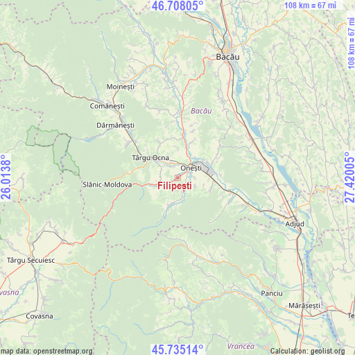
Filipești GPS coordinates[2]
46° 13' 25.5" North, 26° 43' 0.912" East
| Map corner | latitude | longitude |
|---|---|---|
| Upper-left | 46.70805°, | 26.0138° |
| Center: | 46.22375°, | 26.71692° |
| Lower-right: | 45.73514°, | 27.42005° |
| Map W x H: | 108.2×108.2 km | = 67.2×67.2mi |
| max Lat: | 48.23793° ⇑39.8% North |
| Filipești: | 46.22375° |
| min Lat: | ⇓60.2% South 43.65638° |
| min Long | Filipești | max Long |
| 20.31667° | 26.71692° | 29.65403° |
| W 77%⇐ | ⇒23% E |
Elevation
Elevation of Filipești is 242 m = 794 ft, and this is 12.9 m = 42 ft below average elevation for this country.
| Max E: |
1278 m = 4193 ft | 44.2% |
| Avg. | 254.9 m = 836 ft | |
| Filipești | 242 m = 794 ft | |
Min E: |
-2 m = -7 ft | 55.8% |
See also: Romania elevation on elevation.city.
Geographical zone
Filipești is located in North temperate zone (between Tropic of Cancer and the Arctic Circle). Distance of this North polar circle is 2261.6 km =1405.3 mi to North.| Distance of | km | miles | from Filipești |
|---|---|---|---|
| North Pole | 4867.5 | 3024.5 | to North |
| Arctic Circle | 2261.6 | 1405.3 | to North |
| Tropic Cancer | 2533.7 | 1574.4 | to South |
| Equator | 5139.6 | 3193.6 | to South |


Nearby cities:
15 places around Filipești: (largest is in red/bold)
• Bahna
5.1 km =3.2 mi,  273°
273°
• Bogdăneşti
2.7 km =1.7 mi,  253°
253°
• Buciumi
5.7 km =3.5 mi,  114°
114°
• Caşin
3.7 km =2.3 mi,  136°
136°
• Curița
3.7 km =2.3 mi,  185°
185°
• Lupești
6.5 km =4 mi,  168°
168°
• Marginea
6.2 km =3.9 mi,  262°
262°
• Nicorești
5.4 km =3.4 mi,  283°
283°
• Onesti
3.9 km =2.4 mi,  41°
41°
• Pârgăreşti
5.9 km =3.7 mi,  299°
299°
• Răcăuți
5.4 km =3.4 mi,  88°
88°
• Satu Nou
5.4 km =3.4 mi, 295°
• Tuta
4.1 km =2.5 mi,  331°
331°
• Târgu Trotuş
6.1 km =3.8 mi,  321°
321°
• Viișoara
7.9 km =4.9 mi, 327°
Sources, notices
• [Note1] Compared only with cities in Romania existing in our database
• [Src1] Map data: © OpenStreetMap contributors (CC-BY-SA)
• [Src2] Other city data from geonames.org with taken over terms of usage.
• [Src3] Geographical zone / Annual Mean Temperature by Robert A. Rohde @ Wikipedia
