Borzești geodata
Borzești (Bacău) is a section of populated place; located in Romania in Europe/Bucharest (GMT+3) time zone. With population of 689 people, there are 5640 cities with bigger population in this country. Compared to other cities in Romania, 60.6% of cities are located further ↓South; 79.1% of cities are located further ←West and 53.7% of cities have higher elevation than Borzești. Note1


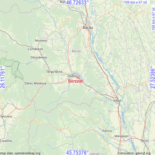
Borzești GPS coordinates[2]
46° 14' 31.92" North, 26° 49' 14.628" East
| Map corner | latitude | longitude |
|---|---|---|
| Upper-left | 46.72633°, | 26.11761° |
| Center: | 46.2422°, | 26.82073° |
| Lower-right: | 45.75376°, | 27.52386° |
| Map W x H: | 108.1×108.1 km | = 67.2×67.2mi |
| max Lat: | 48.23793° ⇑39.4% North |
| Borzești: | 46.2422° |
| min Lat: | ⇓60.6% South 43.65638° |
| min Long | Borzești | max Long |
| 20.31667° | 26.82073° | 29.65403° |
| W 79.1%⇐ | ⇒20.9% E |
Elevation
Elevation of Borzești is 193 m = 633 ft, and this is 61.9 m = 203 ft below average elevation for this country.
| Max E: |
1278 m = 4193 ft | 53.7% |
| Avg. | 254.9 m = 836 ft | |
| Borzești | 193 m = 633 ft | |
Min E: |
-2 m = -7 ft | 46.3% |
See also: Romania elevation on elevation.city.
Geographical zone
Borzești is located in North temperate zone (between Tropic of Cancer and the Arctic Circle). Distance of this North polar circle is 2259.5 km =1404 mi to North.| Distance of | km | miles | from Borzești |
|---|---|---|---|
| North Pole | 4865.4 | 3023.2 | to North |
| Arctic Circle | 2259.5 | 1404 | to North |
| Tropic Cancer | 2535.7 | 1575.6 | to South |
| Equator | 5141.7 | 3194.9 | to South |


Nearby cities:
15 places around Borzești: (largest is in red/bold)
• Bogdana
6.3 km =3.9 mi,  163°
163°
• Buciumi
5.2 km =3.2 mi,  212°
212°
• Caşin
7.2 km =4.5 mi,  229°
229°
• Filipești
8.2 km =5.1 mi,  255°
255°
• Gura Văii
3.4 km =2.1 mi,  6°
6°
• Gutinaș
4.1 km =2.5 mi,  179°
179°
• Negoiești
7 km =4.3 mi,  131°
131°
• Onesti
5.5 km =3.4 mi,  279°
279°
• Păltinata
6.8 km =4.2 mi,  46°
46°
• Răcăuți
3.2 km =2 mi, 233°
• Rădeana
2.9 km =1.8 mi,  151°
151°
• Slobozia
4.7 km =2.9 mi,  328°
328°
• Temelia
6.8 km =4.2 mi,  38°
38°
• Viișoara
5.1 km =3.2 mi,  104°
104°
• Ştefan Cel Mare
4.9 km =3 mi, 147°
Sources, notices
• [Note1] Compared only with cities in Romania existing in our database
• [Src1] Map data: © OpenStreetMap contributors (CC-BY-SA)
• [Src2] Other city data from geonames.org with taken over terms of usage.
• [Src3] Geographical zone / Annual Mean Temperature by Robert A. Rohde @ Wikipedia
