Slăveni geodata
Slăveni (Olt) is a populated place; located in Romania in Europe/Bucharest (GMT+3) time zone. With population of 1,620 people, there are 3021 cities with bigger population in this country. Compared to other cities in Romania, 95.7% of cities are located further ↑North; 60% of cities are located further →East and 87% of cities have higher elevation than Slăveni. Note1


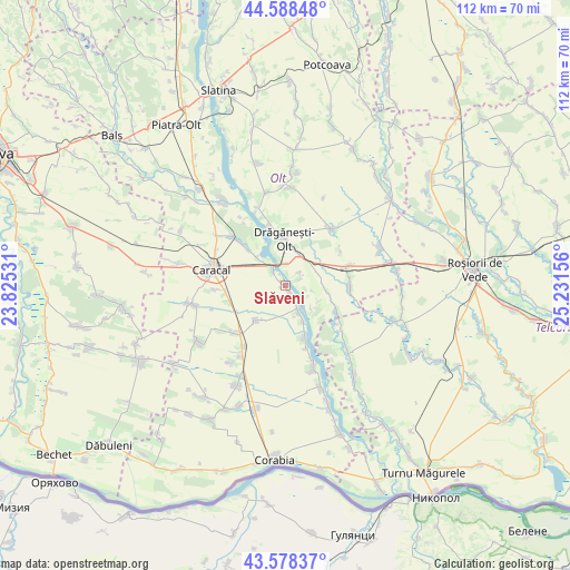
Slăveni GPS coordinates[2]
44° 5' 8.088" North, 24° 31' 42.348" East
| Map corner | latitude | longitude |
|---|---|---|
| Upper-left | 44.58848°, | 23.82531° |
| Center: | 44.08558°, | 24.52843° |
| Lower-right: | 43.57837°, | 25.23156° |
| Map W x H: | 112.3×112.3 km | = 69.8×69.8mi |
| max Lat: | 48.23793° ⇑95.7% North |
| Slăveni: | 44.08558° |
| min Lat: | ⇓4.3% South 43.65638° |
| min Long | Slăveni | max Long |
| 20.31667° | 24.52843° | 29.65403° |
| W 40%⇐ | ⇒60% E |
Elevation
Elevation of Slăveni is 71 m = 233 ft, and this is 183.9 m = 603 ft below average elevation for this country.
| Max E: |
1278 m = 4193 ft | 87% |
| Avg. | 254.9 m = 836 ft | |
| Slăveni | 71 m = 233 ft | |
Min E: |
-2 m = -7 ft | 13% |
See also: Romania elevation on elevation.city.
Geographical zone
Slăveni is located in North temperate zone (between Tropic of Cancer and the Arctic Circle). Distance of this Northern Tropic circle is 2295.9 km =1426.6 mi to South.| Distance of | km | miles | from Slăveni |
|---|---|---|---|
| North Pole | 5105.2 | 3172.2 | to North |
| Arctic Circle | 2499.3 | 1553 | to North |
| Tropic Cancer | 2295.9 | 1426.6 | to South |
| Equator | 4901.9 | 3045.9 | to South |


Nearby cities:
15 places around Slăveni: (largest is in red/bold)
• Berindei
3.8 km =2.4 mi,  47°
47°
• Băbiciu
6.6 km =4.1 mi,  152°
152°
• Cioflanu
2.9 km =1.8 mi,  71°
71°
• Drăgăneşti-Olt
9 km =5.6 mi,  2°
2°
• Dăneasa
7.8 km =4.8 mi,  23°
23°
• Frunzaru
7 km =4.3 mi,  133°
133°
• Fărcaşele
10.4 km =6.5 mi,  313°
313°
• Fărcașu de Jos
7.8 km =4.8 mi, 314°
• Ghimpați
11.1 km =6.9 mi, 313°
• Gostavăţu
0.5 km =0.3 mi,  122°
122°
• Pestra
4.2 km =2.6 mi, 2°
• Scărişoara
10 km =6.2 mi,  162°
162°
• Sprâncenata
8.4 km =5.2 mi,  91°
91°
• Stoeneşti
4.1 km =2.5 mi,  326°
326°
• Traian
9.9 km =6.2 mi,  219°
219°
Sources, notices
• [Note1] Compared only with cities in Romania existing in our database
• [Src1] Map data: © OpenStreetMap contributors (CC-BY-SA)
• [Src2] Other city data from geonames.org with taken over terms of usage.
• [Src3] Geographical zone / Annual Mean Temperature by Robert A. Rohde @ Wikipedia
