Dăneasa geodata
Dăneasa (Olt) is a seat of a second-order administrative division; located in Romania in Europe/Bucharest (GMT+3) time zone. With population of 3,816 people, there are 1255 cities with bigger population in this country. Compared to other cities in Romania, 94.5% of cities are located further ↑North; 59.4% of cities are located further →East and 68.4% of cities have higher elevation than Dăneasa. Note1


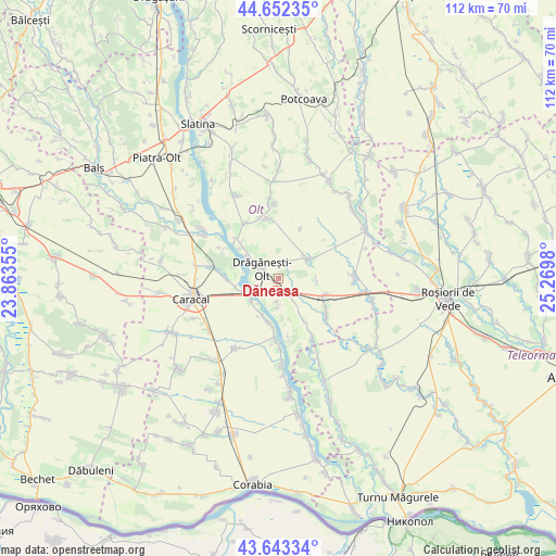
Dăneasa GPS coordinates[2]
44° 9' 0" North, 24° 34' 0.012" East
| Map corner | latitude | longitude |
|---|---|---|
| Upper-left | 44.65235°, | 23.86355° |
| Center: | 44.15°, | 24.56667° |
| Lower-right: | 43.64334°, | 25.2698° |
| Map W x H: | 112.2×112.2 km | = 69.7×69.7mi |
| max Lat: | 48.23793° ⇑94.5% North |
| Dăneasa: | 44.15° |
| min Lat: | ⇓5.5% South 43.65638° |
| min Long | Dăneasa | max Long |
| 20.31667° | 24.56667° | 29.65403° |
| W 40.6%⇐ | ⇒59.4% E |
Elevation
Elevation of Dăneasa is 133 m = 436 ft, and this is 121.9 m = 400 ft below average elevation for this country.
| Max E: |
1278 m = 4193 ft | 68.4% |
| Avg. | 254.9 m = 836 ft | |
| Dăneasa | 133 m = 436 ft | |
Min E: |
-2 m = -7 ft | 31.6% |
See also: Romania elevation on elevation.city.
Geographical zone
Dăneasa is located in North temperate zone (between Tropic of Cancer and the Arctic Circle). Distance of this Northern Tropic circle is 2303.1 km =1431.1 mi to South.| Distance of | km | miles | from Dăneasa |
|---|---|---|---|
| North Pole | 5098 | 3167.7 | to North |
| Arctic Circle | 2492.2 | 1548.6 | to North |
| Tropic Cancer | 2303.1 | 1431.1 | to South |
| Equator | 4909 | 3050.3 | to South |


Nearby cities:
15 places around Dăneasa: (largest is in red/bold)
• Berindei
4.6 km =2.9 mi,  182°
182°
• Cioflanu
6.3 km =3.9 mi, 182°
• Comani
7 km =4.3 mi,  301°
301°
• Crăciunei
7.7 km =4.8 mi,  93°
93°
• Drăgăneşti-Olt
3.2 km =2 mi, 304°
• Fărcaşele
10.6 km =6.6 mi,  270°
270°
• Fărcașu de Jos
8.7 km =5.4 mi,  259°
259°
• Gostavăţu
7.9 km =4.9 mi,  199°
199°
• Mărunţei
9.7 km =6 mi, 304°
• Pestra
4.2 km =2.6 mi,  224°
224°
• Radomireşti
10 km =6.2 mi,  111°
111°
• Slăveni
7.8 km =4.8 mi, 203°
• Sprâncenata
9.1 km =5.7 mi,  144°
144°
• Stoeneşti
6.5 km =4 mi,  235°
235°
• Stoicăneşti
6.5 km =4 mi,  55°
55°
Sources, notices
• [Note1] Compared only with cities in Romania existing in our database
• [Src1] Map data: © OpenStreetMap contributors (CC-BY-SA)
• [Src2] Other city data from geonames.org with taken over terms of usage.
• [Src3] Geographical zone / Annual Mean Temperature by Robert A. Rohde @ Wikipedia
