Băbiciu geodata
Băbiciu (Olt) is a seat of a second-order administrative division; located in Romania in Europe/Bucharest (GMT+3) time zone. With population of 2,337 people, there are 2282 cities with bigger population in this country. Compared to other cities in Romania, 96.5% of cities are located further ↑North; 59.4% of cities are located further →East and 89.2% of cities have higher elevation than Băbiciu. Note1


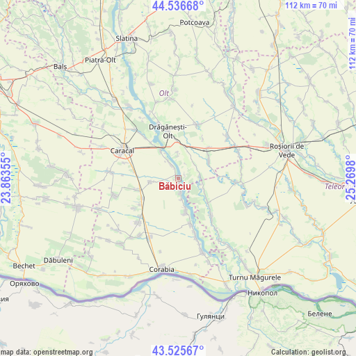
Băbiciu GPS coordinates[2]
44° 1' 59.988" North, 24° 34' 0.012" East
| Map corner | latitude | longitude |
|---|---|---|
| Upper-left | 44.53668°, | 23.86355° |
| Center: | 44.03333°, | 24.56667° |
| Lower-right: | 43.52567°, | 25.2698° |
| Map W x H: | 112.4×112.4 km | = 69.8×69.8mi |
| max Lat: | 48.23793° ⇑96.5% North |
| Băbiciu: | 44.03333° |
| min Lat: | ⇓3.5% South 43.65638° |
| min Long | Băbiciu | max Long |
| 20.31667° | 24.56667° | 29.65403° |
| W 40.6%⇐ | ⇒59.4% E |
Elevation
Elevation of Băbiciu is 62 m = 203 ft, and this is 192.9 m = 633 ft below average elevation for this country.
| Max E: |
1278 m = 4193 ft | 89.2% |
| Avg. | 254.9 m = 836 ft | |
| Băbiciu | 62 m = 203 ft | |
Min E: |
-2 m = -7 ft | 10.8% |
See also: Romania elevation on elevation.city.
Geographical zone
Băbiciu is located in North temperate zone (between Tropic of Cancer and the Arctic Circle). Distance of this Northern Tropic circle is 2290.1 km =1423 mi to South.| Distance of | km | miles | from Băbiciu |
|---|---|---|---|
| North Pole | 5111 | 3175.8 | to North |
| Arctic Circle | 2505.1 | 1556.6 | to North |
| Tropic Cancer | 2290.1 | 1423 | to South |
| Equator | 4896 | 3042.2 | to South |


Nearby cities:
15 places around Băbiciu: (largest is in red/bold)
• Beciu
8.6 km =5.3 mi,  112°
112°
• Berindei
8.4 km =5.2 mi,  358°
358°
• Bârseștii de Sus
8 km =5 mi,  90°
90°
• Cioflanu
6.7 km =4.2 mi, 357°
• Frunzaru
2.2 km =1.4 mi,  63°
63°
• Gostavăţu
6.2 km =3.9 mi,  334°
334°
• Jieni
9.4 km =5.8 mi,  166°
166°
• Pestra
10.4 km =6.5 mi,  343°
343°
• Plăviceni
6.9 km =4.3 mi, 171°
• Scărişoara
3.7 km =2.3 mi,  180°
180°
• Slăveni
6.6 km =4.1 mi, 332°
• Smârdan
8.1 km =5 mi,  102°
102°
• Sprâncenata
7.7 km =4.8 mi,  43°
43°
• Stoeneşti
10.7 km =6.6 mi, 330°
• Traian
9.5 km =5.9 mi,  258°
258°
Sources, notices
• [Note1] Compared only with cities in Romania existing in our database
• [Src1] Map data: © OpenStreetMap contributors (CC-BY-SA)
• [Src2] Other city data from geonames.org with taken over terms of usage.
• [Src3] Geographical zone / Annual Mean Temperature by Robert A. Rohde @ Wikipedia
