Slătioarele geodata
Slătioarele (Ialomiţa) is a populated place; located in Romania in Europe/Bucharest (GMT+3) time zone. With population of 524 people, there are 6827 cities with bigger population in this country. Compared to other cities in Romania, 77.1% of cities are located further ↑North; 73% of cities are located further ←West and 88.5% of cities have higher elevation than Slătioarele. Note1


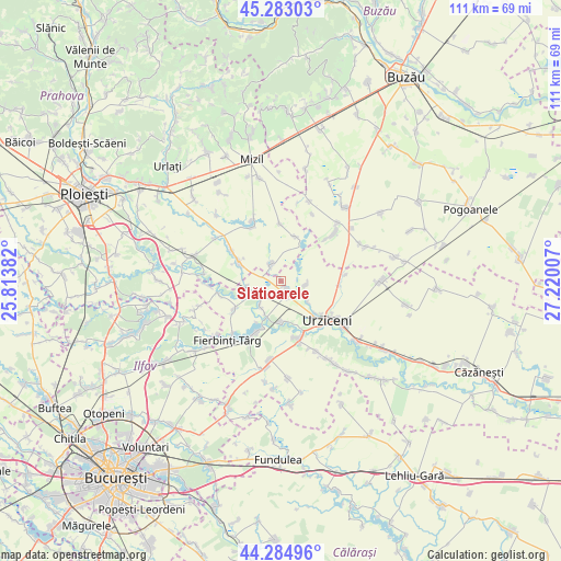
Slătioarele GPS coordinates[2]
44° 47' 10.14" North, 26° 31' 0.984" East
| Map corner | latitude | longitude |
|---|---|---|
| Upper-left | 45.28303°, | 25.81382° |
| Center: | 44.78615°, | 26.51694° |
| Lower-right: | 44.28496°, | 27.22007° |
| Map W x H: | 111×111 km | = 69×69mi |
| max Lat: | 48.23793° ⇑77.1% North |
| Slătioarele: | 44.78615° |
| min Lat: | ⇓22.9% South 43.65638° |
| min Long | Slătioarele | max Long |
| 20.31667° | 26.51694° | 29.65403° |
| W 73%⇐ | ⇒27% E |
Elevation
Elevation of Slătioarele is 65 m = 213 ft, and this is 189.9 m = 623 ft below average elevation for this country.
| Max E: |
1278 m = 4193 ft | 88.5% |
| Avg. | 254.9 m = 836 ft | |
| Slătioarele | 65 m = 213 ft | |
Min E: |
-2 m = -7 ft | 11.5% |
See also: Romania elevation on elevation.city.
Geographical zone
Slătioarele is located in North temperate zone (between Tropic of Cancer and the Arctic Circle). Distance of this Northern Tropic circle is 2373.8 km =1475 mi to South.| Distance of | km | miles | from Slătioarele |
|---|---|---|---|
| North Pole | 5027.3 | 3123.8 | to North |
| Arctic Circle | 2421.4 | 1504.6 | to North |
| Tropic Cancer | 2373.8 | 1475 | to South |
| Equator | 4979.8 | 3094.3 | to South |


Nearby cities:
15 places around Slătioarele: (largest is in red/bold)
• Adâncata
6.9 km =4.3 mi,  251°
251°
• Armăşeşti
6.6 km =4.1 mi,  127°
127°
• Boldeşti
9.2 km =5.7 mi,  15°
15°
• Bărbulești
9.3 km =5.8 mi,  135°
135°
• Cioranii de Jos
8.6 km =5.3 mi,  293°
293°
• Cioranii de Sus
11.3 km =7 mi,  301°
301°
• Dridu
10.9 km =6.8 mi,  208°
208°
• Dridu-Snagov
9.6 km =6 mi, 211°
• Gradiștea
11.3 km =7 mi,  359°
359°
• Jilavele
2.5 km =1.6 mi,  149°
149°
• Maia
10.7 km =6.6 mi,  238°
238°
• Malu Roșu
5 km =3.1 mi,  96°
96°
• Moldoveni
8 km =5 mi,  178°
178°
• Patru Frați
6.6 km =4.1 mi, 213°
• Sălciile
4.3 km =2.7 mi,  321°
321°
Sources, notices
• [Note1] Compared only with cities in Romania existing in our database
• [Src1] Map data: © OpenStreetMap contributors (CC-BY-SA)
• [Src2] Other city data from geonames.org with taken over terms of usage.
• [Src3] Geographical zone / Annual Mean Temperature by Robert A. Rohde @ Wikipedia
