Boldeşti geodata
Boldeşti (Prahova) is a seat of a second-order administrative division; located in Romania in Europe/Bucharest (GMT+3) time zone. With population of 1,952 people, there are 2645 cities with bigger population in this country. Compared to other cities in Romania, 74.4% of cities are located further ↑North; 73.6% of cities are located further ←West and 86.1% of cities have higher elevation than Boldeşti. Note1


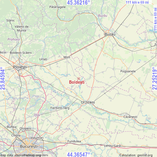
Boldeşti GPS coordinates[2]
44° 51' 57.492" North, 26° 32' 56.616" East
| Map corner | latitude | longitude |
|---|---|---|
| Upper-left | 45.36216°, | 25.84594° |
| Center: | 44.86597°, | 26.54906° |
| Lower-right: | 44.36547°, | 27.25219° |
| Map W x H: | 110.8×110.8 km | = 68.8×68.8mi |
| max Lat: | 48.23793° ⇑74.4% North |
| Boldeşti: | 44.86597° |
| min Lat: | ⇓25.6% South 43.65638° |
| min Long | Boldeşti | max Long |
| 20.31667° | 26.54906° | 29.65403° |
| W 73.6%⇐ | ⇒26.4% E |
Elevation
Elevation of Boldeşti is 75 m = 246 ft, and this is 179.9 m = 590 ft below average elevation for this country.
| Max E: |
1278 m = 4193 ft | 86.1% |
| Avg. | 254.9 m = 836 ft | |
| Boldeşti | 75 m = 246 ft | |
Min E: |
-2 m = -7 ft | 13.9% |
See also: Romania elevation on elevation.city.
Geographical zone
Boldeşti is located in North temperate zone (between Tropic of Cancer and the Arctic Circle). Distance of this Northern Tropic circle is 2382.7 km =1480.5 mi to South.| Distance of | km | miles | from Boldeşti |
|---|---|---|---|
| North Pole | 5018.4 | 3118.3 | to North |
| Arctic Circle | 2412.5 | 1499.1 | to North |
| Tropic Cancer | 2382.7 | 1480.5 | to South |
| Equator | 4988.6 | 3099.8 | to South |


Nearby cities:
15 places around Boldeşti: (largest is in red/bold)
• Amaru
8 km =5 mi,  19°
19°
• Ciocârlia
11.8 km =7.3 mi,  128°
128°
• Cioranii de Jos
11.8 km =7.3 mi,  242°
242°
• Căldărușanca
11.6 km =7.2 mi,  82°
82°
• Dulbanu
5.9 km =3.7 mi,  40°
40°
• Fulga de Jos
8.6 km =5.3 mi,  281°
281°
• Fulga de Sus
8.7 km =5.4 mi,  295°
295°
• Glodeanu-Sărat
8 km =5 mi,  89°
89°
• Gradiștea
3.6 km =2.2 mi,  312°
312°
• Jilavele
11.1 km =6.9 mi,  186°
186°
• Malu Roșu
9.8 km =6.1 mi,  165°
165°
• Mihăileşti
10.8 km =6.7 mi,  58°
58°
• Pitulicea
9.3 km =5.8 mi,  72°
72°
• Slătioarele
9.2 km =5.7 mi,  195°
195°
• Sălciile
7.5 km =4.7 mi,  223°
223°
Sources, notices
• [Note1] Compared only with cities in Romania existing in our database
• [Src1] Map data: © OpenStreetMap contributors (CC-BY-SA)
• [Src2] Other city data from geonames.org with taken over terms of usage.
• [Src3] Geographical zone / Annual Mean Temperature by Robert A. Rohde @ Wikipedia
