Armăşeşti geodata
Armăşeşti (Ialomiţa) is a seat of a second-order administrative division; located in Romania in Europe/Bucharest (GMT+3) time zone. With population of 7,243 people, there are 372 cities with bigger population in this country. Compared to other cities in Romania, 78.4% of cities are located further ↑North; 74.3% of cities are located further ←West and 89.5% of cities have higher elevation than Armăşeşti. Note1


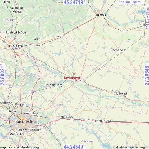
Armăşeşti GPS coordinates[2]
44° 45' 0" North, 26° 34' 59.988" East
| Map corner | latitude | longitude |
|---|---|---|
| Upper-left | 45.24719°, | 25.88021° |
| Center: | 44.75°, | 26.58333° |
| Lower-right: | 44.24849°, | 27.28646° |
| Map W x H: | 111×111 km | = 69×69mi |
| max Lat: | 48.23793° ⇑78.4% North |
| Armăşeşti: | 44.75° |
| min Lat: | ⇓21.6% South 43.65638° |
| min Long | Armăşeşti | max Long |
| 20.31667° | 26.58333° | 29.65403° |
| W 74.3%⇐ | ⇒25.7% E |
Elevation
Elevation of Armăşeşti is 60 m = 197 ft, and this is 194.9 m = 639 ft below average elevation for this country.
| Max E: |
1278 m = 4193 ft | 89.5% |
| Avg. | 254.9 m = 836 ft | |
| Armăşeşti | 60 m = 197 ft | |
Min E: |
-2 m = -7 ft | 10.5% |
See also: Romania elevation on elevation.city.
Geographical zone
Armăşeşti is located in North temperate zone (between Tropic of Cancer and the Arctic Circle). Distance of this Northern Tropic circle is 2369.8 km =1472.5 mi to South.| Distance of | km | miles | from Armăşeşti |
|---|---|---|---|
| North Pole | 5031.3 | 3126.3 | to North |
| Arctic Circle | 2425.4 | 1507.1 | to North |
| Tropic Cancer | 2369.8 | 1472.5 | to South |
| Equator | 4975.7 | 3091.8 | to South |


Nearby cities:
15 places around Armăşeşti: (largest is in red/bold)
• Alexeni
11.8 km =7.3 mi,  128°
128°
• Borănești
10.1 km =6.3 mi,  170°
170°
• Bărbulești
2.9 km =1.8 mi,  154°
154°
• Ciocârlia
8.6 km =5.3 mi,  49°
49°
• Coşereni
7.5 km =4.7 mi,  190°
190°
• Dridu
11.9 km =7.4 mi,  242°
242°
• Dridu-Snagov
11.1 km =6.9 mi,  248°
248°
• Jilavele
4.4 km =2.7 mi,  295°
295°
• Malu Roșu
3.4 km =2.1 mi,  354°
354°
• Manasia
8.6 km =5.3 mi, 130°
• Moldoveni
6.5 km =4 mi,  232°
232°
• Patru Frați
9 km =5.6 mi,  260°
260°
• Slătioarele
6.6 km =4.1 mi,  307°
307°
• Sălciile
10.8 km =6.7 mi, 313°
• Urziceni
5.4 km =3.4 mi, 133°
Sources, notices
• [Note1] Compared only with cities in Romania existing in our database
• [Src1] Map data: © OpenStreetMap contributors (CC-BY-SA)
• [Src2] Other city data from geonames.org with taken over terms of usage.
• [Src3] Geographical zone / Annual Mean Temperature by Robert A. Rohde @ Wikipedia
