Slatina geodata
Slatina (Arges) is a populated place; located in Romania in Europe/Bucharest (GMT+3) time zone. With population of 599 people, there are 6213 cities with bigger population in this country. Compared to other cities in Romania, 57.7% of cities are located further ↑North; 55.3% of cities are located further →East and 96.1% of cities have lower elevation than Slatina. Note1


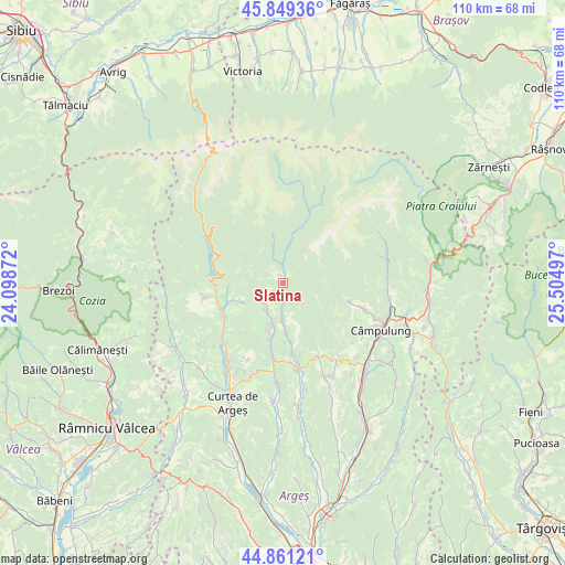
Slatina GPS coordinates[2]
45° 21' 26.784" North, 24° 48' 6.624" East
| Map corner | latitude | longitude |
|---|---|---|
| Upper-left | 45.84936°, | 24.09872° |
| Center: | 45.35744°, | 24.80184° |
| Lower-right: | 44.86121°, | 25.50497° |
| Map W x H: | 109.9×109.9 km | = 68.3×68.3mi |
| max Lat: | 48.23793° ⇑57.7% North |
| Slatina: | 45.35744° |
| min Lat: | ⇓42.3% South 43.65638° |
| min Long | Slatina | max Long |
| 20.31667° | 24.80184° | 29.65403° |
| W 44.7%⇐ | ⇒55.3% E |
Elevation
Elevation of Slatina is 672 m = 2205 ft, and this is 417.1 m = 1368 ft above average elevation for this country.
| Max E: |
1278 m = 4193 ft | 3.9% |
| Slatina | 672 m 2205 ft | |
| Avg. | 254.9 m = 836 ft | |
Min E: |
-2 m = -7 ft | 96.1% |
See also: Romania elevation on elevation.city.
Geographical zone
Slatina is located in North temperate zone (between Tropic of Cancer and the Arctic Circle). Distance of this North polar circle is 2357.9 km =1465.1 mi to North.| Distance of | km | miles | from Slatina |
|---|---|---|---|
| North Pole | 4963.8 | 3084.4 | to North |
| Arctic Circle | 2357.9 | 1465.1 | to North |
| Tropic Cancer | 2437.4 | 1514.5 | to South |
| Equator | 5043.3 | 3133.8 | to South |


Nearby cities:
15 places around Slatina: (largest is in red/bold)
• Brădetu
6.1 km =3.8 mi,  210°
210°
• Brăduleţ
8.7 km =5.4 mi,  198°
198°
• Bucșenești
12.9 km =8 mi,  240°
240°
• Corbeni
13.5 km =8.4 mi, 241°
• Corbi
8.2 km =5.1 mi,  181°
181°
• Corbșori
11.7 km =7.3 mi,  171°
171°
• Căpățânenii Pământeni
12.7 km =7.9 mi,  249°
249°
• Căpățânenii Ungureni
13.4 km =8.3 mi,  258°
258°
• Galeșu
10 km =6.2 mi, 197°
• Jgheaburi
8.5 km =5.3 mi, 178°
• Nucşoara
3 km =1.9 mi, 208°
• Poienari
12.7 km =7.9 mi, 249°
• Rotunda
13.7 km =8.5 mi, 236°
• Sboghițești
3 km =1.9 mi, 170°
• Stănești
14.5 km =9 mi, 169°
Sources, notices
• [Note1] Compared only with cities in Romania existing in our database
• [Src1] Map data: © OpenStreetMap contributors (CC-BY-SA)
• [Src2] Other city data from geonames.org with taken over terms of usage.
• [Src3] Geographical zone / Annual Mean Temperature by Robert A. Rohde @ Wikipedia
