Rotunda geodata
Rotunda (Arges) is a populated place; located in Romania in Europe/Bucharest (GMT+3) time zone. With population of 679 people, there are 5694 cities with bigger population in this country. Compared to other cities in Romania, 59.2% of cities are located further ↑North; 57.9% of cities are located further →East and 92.5% of cities have lower elevation than Rotunda. Note1


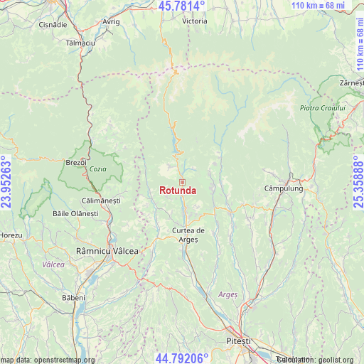
Rotunda GPS coordinates[2]
45° 17' 20.004" North, 24° 39' 20.7" East
| Map corner | latitude | longitude |
|---|---|---|
| Upper-left | 45.7814°, | 23.95263° |
| Center: | 45.28889°, | 24.65575° |
| Lower-right: | 44.79206°, | 25.35888° |
| Map W x H: | 110×110 km | = 68.4×68.4mi |
| max Lat: | 48.23793° ⇑59.2% North |
| Rotunda: | 45.28889° |
| min Lat: | ⇓40.8% South 43.65638° |
| min Long | Rotunda | max Long |
| 20.31667° | 24.65575° | 29.65403° |
| W 42.1%⇐ | ⇒57.9% E |
Elevation
Elevation of Rotunda is 561 m = 1841 ft, and this is 306.1 m = 1004 ft above average elevation for this country.
| Max E: |
1278 m = 4193 ft | 7.5% |
| Rotunda | 561 m 1841 ft | |
| Avg. | 254.9 m = 836 ft | |
Min E: |
-2 m = -7 ft | 92.5% |
See also: Romania elevation on elevation.city.
Geographical zone
Rotunda is located in North temperate zone (between Tropic of Cancer and the Arctic Circle). Distance of this North polar circle is 2365.5 km =1469.9 mi to North.| Distance of | km | miles | from Rotunda |
|---|---|---|---|
| North Pole | 4971.4 | 3089.1 | to North |
| Arctic Circle | 2365.5 | 1469.9 | to North |
| Tropic Cancer | 2429.7 | 1509.7 | to South |
| Equator | 5035.7 | 3129 | to South |


Nearby cities:
15 places around Rotunda: (largest is in red/bold)
• Albeştii Pământeni
8.1 km =5 mi,  173°
173°
• Albeştii de Argeş
8.1 km =5 mi, 173°
• Albeștii Ungureni
7.2 km =4.5 mi, 169°
• Arefu
6.6 km =4.1 mi,  318°
318°
• Brătești
8.2 km =5.1 mi,  149°
149°
• Bucșenești
1.4 km =0.9 mi,  8°
8°
• Bărăști
6.1 km =3.8 mi,  229°
229°
• Cicănești
6.2 km =3.9 mi,  219°
219°
• Corbeni
1.3 km =0.8 mi,  339°
339°
• Căpățânenii Pământeni
3.1 km =1.9 mi,  351°
351°
• Căpățânenii Ungureni
5.2 km =3.2 mi, 340°
• Oeștii Pământeni
4.1 km =2.5 mi,  179°
179°
• Oeștii Ungureni
4 km =2.5 mi,  187°
187°
• Poienari
3.1 km =1.9 mi, 351°
• Urechești
4.5 km =2.8 mi, 223°
Sources, notices
• [Note1] Compared only with cities in Romania existing in our database
• [Src1] Map data: © OpenStreetMap contributors (CC-BY-SA)
• [Src2] Other city data from geonames.org with taken over terms of usage.
• [Src3] Geographical zone / Annual Mean Temperature by Robert A. Rohde @ Wikipedia
