Sâmbăteni geodata
Sâmbăteni (Arad) is a populated place; located in Romania in Europe/Bucharest (GMT+3) time zone. With population of 1,710 people, there are 2915 cities with bigger population in this country. Compared to other cities in Romania, 58.3% of cities are located further ↓South; 97.5% of cities are located further →East and 72.7% of cities have higher elevation than Sâmbăteni. Note1


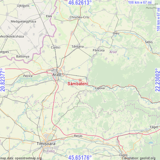
Sâmbăteni GPS coordinates[2]
46° 8' 27.96" North, 21° 31' 36.804" East
| Map corner | latitude | longitude |
|---|---|---|
| Upper-left | 46.62613°, | 20.82377° |
| Center: | 46.1411°, | 21.52689° |
| Lower-right: | 45.65176°, | 22.23002° |
| Map W x H: | 108.3×108.3 km | = 67.3×67.3mi |
| max Lat: | 48.23793° ⇑41.7% North |
| Sâmbăteni: | 46.1411° |
| min Lat: | ⇓58.3% South 43.65638° |
| min Long | Sâmbăteni | max Long |
| 20.31667° | 21.52689° | 29.65403° |
| W 2.5%⇐ | ⇒97.5% E |
Elevation
Elevation of Sâmbăteni is 118 m = 387 ft, and this is 136.9 m = 449 ft below average elevation for this country.
| Max E: |
1278 m = 4193 ft | 72.7% |
| Avg. | 254.9 m = 836 ft | |
| Sâmbăteni | 118 m = 387 ft | |
Min E: |
-2 m = -7 ft | 27.3% |
See also: Romania elevation on elevation.city.
Geographical zone
Sâmbăteni is located in North temperate zone (between Tropic of Cancer and the Arctic Circle). Distance of this North polar circle is 2270.8 km =1411 mi to North.| Distance of | km | miles | from Sâmbăteni |
|---|---|---|---|
| North Pole | 4876.7 | 3030.2 | to North |
| Arctic Circle | 2270.8 | 1411 | to North |
| Tropic Cancer | 2524.5 | 1568.7 | to South |
| Equator | 5130.4 | 3187.9 | to South |


Nearby cities:
15 places around Sâmbăteni: (largest is in red/bold)
• Alioș
11.8 km =7.3 mi,  192°
192°
• Aluniș
6 km =3.7 mi,  208°
208°
• Chesinț
10.9 km =6.8 mi,  158°
158°
• Covăsinţ
8.6 km =5.3 mi,  40°
40°
• Cuvin
6.1 km =3.8 mi,  57°
57°
• Frumușeni
6.6 km =4.1 mi,  229°
229°
• Fântânele
11.2 km =7 mi,  260°
260°
• Ghioroc
4.5 km =2.8 mi,  77°
77°
• Horia
9 km =5.6 mi,  326°
326°
• Miniș
6.1 km =3.8 mi,  95°
95°
• Mândruloc
4.8 km =3 mi,  280°
280°
• Neudorf
10.7 km =6.6 mi,  138°
138°
• Păuliş
5.1 km =3.2 mi,  121°
121°
• Vladimirescu
10.1 km =6.3 mi,  286°
286°
• Zăbrani
8.5 km =5.3 mi,  167°
167°
Sources, notices
• [Note1] Compared only with cities in Romania existing in our database
• [Src1] Map data: © OpenStreetMap contributors (CC-BY-SA)
• [Src2] Other city data from geonames.org with taken over terms of usage.
• [Src3] Geographical zone / Annual Mean Temperature by Robert A. Rohde @ Wikipedia
