Covăsinţ geodata
Covăsinţ (Arad) is a seat of a second-order administrative division; located in Romania in Europe/Bucharest (GMT+3) time zone. With population of 2,613 people, there are 2051 cities with bigger population in this country. Compared to other cities in Romania, 59.5% of cities are located further ↓South; 97% of cities are located further →East and 73.6% of cities have higher elevation than Covăsinţ. Note1


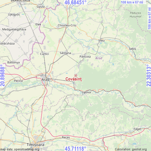
Covăsinţ GPS coordinates[2]
46° 12' 0" North, 21° 36' 0" East
| Map corner | latitude | longitude |
|---|---|---|
| Upper-left | 46.68451°, | 20.89688° |
| Center: | 46.2°, | 21.6° |
| Lower-right: | 45.71118°, | 22.30313° |
| Map W x H: | 108.2×108.2 km | = 67.2×67.2mi |
| max Lat: | 48.23793° ⇑40.5% North |
| Covăsinţ: | 46.2° |
| min Lat: | ⇓59.5% South 43.65638° |
| min Long | Covăsinţ | max Long |
| 20.31667° | 21.6° | 29.65403° |
| W 3%⇐ | ⇒97% E |
Elevation
Elevation of Covăsinţ is 115 m = 377 ft, and this is 139.9 m = 459 ft below average elevation for this country.
| Max E: |
1278 m = 4193 ft | 73.6% |
| Avg. | 254.9 m = 836 ft | |
| Covăsinţ | 115 m = 377 ft | |
Min E: |
-2 m = -7 ft | 26.4% |
See also: Romania elevation on elevation.city.
Geographical zone
Covăsinţ is located in North temperate zone (between Tropic of Cancer and the Arctic Circle). Distance of this North polar circle is 2264.2 km =1406.9 mi to North.| Distance of | km | miles | from Covăsinţ |
|---|---|---|---|
| North Pole | 4870.1 | 3026.1 | to North |
| Arctic Circle | 2264.2 | 1406.9 | to North |
| Tropic Cancer | 2531 | 1572.7 | to South |
| Equator | 5137 | 3192 | to South |


Nearby cities:
15 places around Covăsinţ: (largest is in red/bold)
• Agrișu Mare
14.4 km =8.9 mi,  56°
56°
• Cuvin
3.4 km =2.1 mi,  188°
188°
• Galșa
10.6 km =6.6 mi,  21°
21°
• Ghioroc
5.7 km =3.5 mi, 192°
• Horia
10.6 km =6.6 mi,  275°
275°
• Lipova
14.2 km =8.8 mi,  148°
148°
• Miniș
7.1 km =4.4 mi,  176°
176°
• Mândruloc
11.8 km =7.3 mi,  241°
241°
• Mâsca
12.8 km =8 mi,  29°
29°
• Măderat
13.6 km =8.5 mi,  39°
39°
• Păuliş
9.4 km =5.8 mi, 187°
• Radna
13.5 km =8.4 mi, 150°
• Sâmbăteni
8.6 km =5.3 mi,  220°
220°
• Şiria
7.8 km =4.8 mi, 19°
• Șoimoș
13.9 km =8.6 mi,  138°
138°
Sources, notices
• [Note1] Compared only with cities in Romania existing in our database
• [Src1] Map data: © OpenStreetMap contributors (CC-BY-SA)
• [Src2] Other city data from geonames.org with taken over terms of usage.
• [Src3] Geographical zone / Annual Mean Temperature by Robert A. Rohde @ Wikipedia
