Ghioroc geodata
Ghioroc (Arad) is a seat of a second-order administrative division; located in Romania in Europe/Bucharest (GMT+3) time zone. With population of 3,998 people, there are 1164 cities with bigger population in this country. Compared to other cities in Romania, 58.4% of cities are located further ↓South; 97.2% of cities are located further →East and 71.9% of cities have higher elevation than Ghioroc. Note1


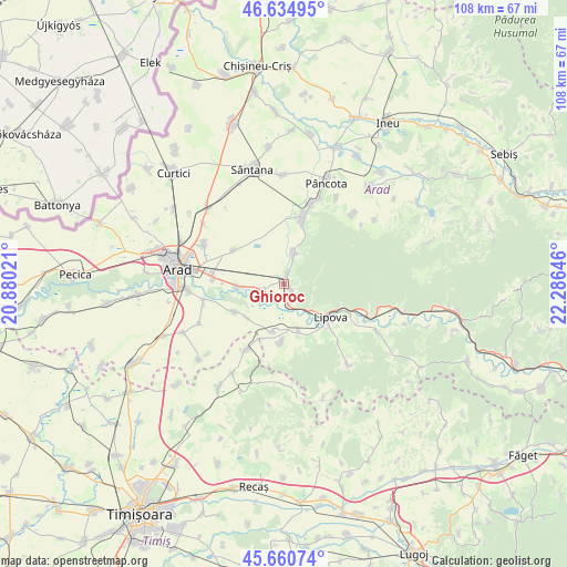
Ghioroc GPS coordinates[2]
46° 9' 0" North, 21° 34' 59.988" East
| Map corner | latitude | longitude |
|---|---|---|
| Upper-left | 46.63495°, | 20.88021° |
| Center: | 46.15°, | 21.58333° |
| Lower-right: | 45.66074°, | 22.28646° |
| Map W x H: | 108.3×108.3 km | = 67.3×67.3mi |
| max Lat: | 48.23793° ⇑41.6% North |
| Ghioroc: | 46.15° |
| min Lat: | ⇓58.4% South 43.65638° |
| min Long | Ghioroc | max Long |
| 20.31667° | 21.58333° | 29.65403° |
| W 2.8%⇐ | ⇒97.2% E |
Elevation
Elevation of Ghioroc is 120 m = 394 ft, and this is 134.9 m = 443 ft below average elevation for this country.
| Max E: |
1278 m = 4193 ft | 71.9% |
| Avg. | 254.9 m = 836 ft | |
| Ghioroc | 120 m = 394 ft | |
Min E: |
-2 m = -7 ft | 28.1% |
See also: Romania elevation on elevation.city.
Geographical zone
Ghioroc is located in North temperate zone (between Tropic of Cancer and the Arctic Circle). Distance of this North polar circle is 2269.8 km =1410.4 mi to North.| Distance of | km | miles | from Ghioroc |
|---|---|---|---|
| North Pole | 4875.7 | 3029.6 | to North |
| Arctic Circle | 2269.8 | 1410.4 | to North |
| Tropic Cancer | 2525.5 | 1569.3 | to South |
| Equator | 5131.4 | 3188.5 | to South |


Nearby cities:
15 places around Ghioroc: (largest is in red/bold)
• Aluniș
9.6 km =6 mi,  229°
229°
• Chesinț
11.2 km =7 mi,  181°
181°
• Covăsinţ
5.7 km =3.5 mi,  12°
12°
• Cuvin
2.4 km =1.5 mi,  19°
19°
• Frumușeni
10.8 km =6.7 mi,  240°
240°
• Horia
11.3 km =7 mi,  305°
305°
• Lipova
10.9 km =6.8 mi,  127°
127°
• Miniș
2.3 km =1.4 mi, 131°
• Mândruloc
9.1 km =5.7 mi,  269°
269°
• Neudorf
9.4 km =5.8 mi,  162°
162°
• Păuliş
3.7 km =2.3 mi, 180°
• Radna
10.1 km =6.3 mi, 127°
• Sâmbăteni
4.5 km =2.8 mi,  257°
257°
• Zăbrani
9.6 km =6 mi,  195°
195°
• Șoimoș
11.6 km =7.2 mi,  114°
114°
Sources, notices
• [Note1] Compared only with cities in Romania existing in our database
• [Src1] Map data: © OpenStreetMap contributors (CC-BY-SA)
• [Src2] Other city data from geonames.org with taken over terms of usage.
• [Src3] Geographical zone / Annual Mean Temperature by Robert A. Rohde @ Wikipedia
