Şieuţ geodata
Şieuţ (Bistriţa-Năsăud) is a seat of a second-order administrative division; located in Romania in Europe/Bucharest (GMT+3) time zone. With population of 2,754 people, there are 1944 cities with bigger population in this country. Compared to other cities in Romania, 78.5% of cities are located further ↓South; 58.2% of cities are located further →East and 89% of cities have lower elevation than Şieuţ. Note1


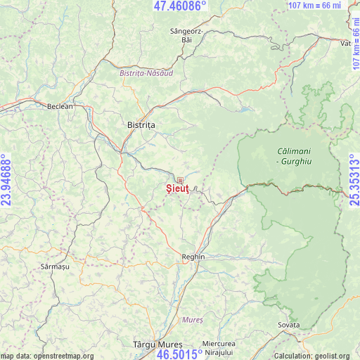
Şieuţ GPS coordinates[2]
46° 58' 59.988" North, 24° 39' 0" East
| Map corner | latitude | longitude |
|---|---|---|
| Upper-left | 47.46086°, | 23.94688° |
| Center: | 46.98333°, | 24.65° |
| Lower-right: | 46.5015°, | 25.35313° |
| Map W x H: | 106.7×106.7 km | = 66.3×66.3mi |
| max Lat: | 48.23793° ⇑21.5% North |
| Şieuţ: | 46.98333° |
| min Lat: | ⇓78.5% South 43.65638° |
| min Long | Şieuţ | max Long |
| 20.31667° | 24.65° | 29.65403° |
| W 41.8%⇐ | ⇒58.2% E |
Elevation
Elevation of Şieuţ is 497 m = 1631 ft, and this is 242.1 m = 794 ft above average elevation for this country.
| Max E: |
1278 m = 4193 ft | 11% |
| Şieuţ | 497 m 1631 ft | |
| Avg. | 254.9 m = 836 ft | |
Min E: |
-2 m = -7 ft | 89% |
See also: Romania elevation on elevation.city.
Geographical zone
Şieuţ is located in North temperate zone (between Tropic of Cancer and the Arctic Circle). Distance of this North polar circle is 2177.1 km =1352.8 mi to North.| Distance of | km | miles | from Şieuţ |
|---|---|---|---|
| North Pole | 4783 | 2972 | to North |
| Arctic Circle | 2177.1 | 1352.8 | to North |
| Tropic Cancer | 2618.1 | 1626.8 | to South |
| Equator | 5224.1 | 3246.1 | to South |


Nearby cities:
15 places around Şieuţ: (largest is in red/bold)
• Ardan
5.4 km =3.4 mi,  18°
18°
• Batoş
11.2 km =7 mi,  173°
173°
• Budacu de Sus
8.7 km =5.4 mi,  3°
3°
• Dumitrița
10 km =6.2 mi,  349°
349°
• Gledin
5.2 km =3.2 mi,  120°
120°
• Monor
4.2 km =2.6 mi, 116°
• Mărişelu
10.8 km =6.7 mi,  290°
290°
• Pinticu
9.5 km =5.9 mi,  239°
239°
• Posmuș
5.1 km =3.2 mi,  270°
270°
• Ruștior
1.9 km =1.2 mi,  55°
55°
• Râpa de Jos
10.2 km =6.3 mi, 118°
• Sebiș
5.7 km =3.5 mi, 62°
• Uila
6.2 km =3.9 mi,  202°
202°
• Vătava
9 km =5.6 mi,  101°
101°
• Şieu
5.3 km =3.3 mi,  314°
314°
Sources, notices
• [Note1] Compared only with cities in Romania existing in our database
• [Src1] Map data: © OpenStreetMap contributors (CC-BY-SA)
• [Src2] Other city data from geonames.org with taken over terms of usage.
• [Src3] Geographical zone / Annual Mean Temperature by Robert A. Rohde @ Wikipedia
