Batoş geodata
Batoş (Mureş) is a seat of a second-order administrative division; located in Romania in Europe/Bucharest (GMT+3) time zone. With population of 4,107 people, there are 1127 cities with bigger population in this country. Compared to other cities in Romania, 76% of cities are located further ↓South; 57.7% of cities are located further →East and 86.9% of cities have lower elevation than Batoş. Note1


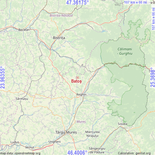
Batoş GPS coordinates[2]
46° 52' 59.988" North, 24° 40' 0.012" East
| Map corner | latitude | longitude |
|---|---|---|
| Upper-left | 47.36175°, | 23.96355° |
| Center: | 46.88333°, | 24.66667° |
| Lower-right: | 46.4006°, | 25.3698° |
| Map W x H: | 106.9×106.9 km | = 66.4×66.4mi |
| max Lat: | 48.23793° ⇑24% North |
| Batoş: | 46.88333° |
| min Lat: | ⇓76% South 43.65638° |
| min Long | Batoş | max Long |
| 20.31667° | 24.66667° | 29.65403° |
| W 42.3%⇐ | ⇒57.7% E |
Elevation
Elevation of Batoş is 468 m = 1535 ft, and this is 213.1 m = 699 ft above average elevation for this country.
| Max E: |
1278 m = 4193 ft | 13.1% |
| Batoş | 468 m 1535 ft | |
| Avg. | 254.9 m = 836 ft | |
Min E: |
-2 m = -7 ft | 86.9% |
See also: Romania elevation on elevation.city.
Geographical zone
Batoş is located in North temperate zone (between Tropic of Cancer and the Arctic Circle). Distance of this North polar circle is 2188.2 km =1359.7 mi to North.| Distance of | km | miles | from Batoş |
|---|---|---|---|
| North Pole | 4794.1 | 2978.9 | to North |
| Arctic Circle | 2188.2 | 1359.7 | to North |
| Tropic Cancer | 2607 | 1619.9 | to South |
| Equator | 5212.9 | 3239.1 | to South |


Nearby cities:
15 places around Batoş: (largest is in red/bold)
• Aluniş
10.1 km =6.3 mi,  83°
83°
• Brâncoveneşti
7.7 km =4.8 mi,  113°
113°
• Dedrad
6.4 km =4 mi,  185°
185°
• Frunzeni
10.7 km =6.6 mi,  224°
224°
• Gledin
9.1 km =5.7 mi,  20°
20°
• Goreni
3.3 km =2.1 mi, 194°
• Logig
7.1 km =4.4 mi,  266°
266°
• Luieriu
5.3 km =3.3 mi,  134°
134°
• Lunca
8.5 km =5.3 mi,  244°
244°
• Lunca Mureșului
9.5 km =5.9 mi,  96°
96°
• Monor
9.6 km =6 mi, 15°
• Râpa de Jos
9.9 km =6.2 mi,  51°
51°
• Suseni
9.2 km =5.7 mi,  147°
147°
• Uila
6.5 km =4 mi,  325°
325°
• Vălenii de Mureș
10 km =6.2 mi, 84°
Sources, notices
• [Note1] Compared only with cities in Romania existing in our database
• [Src1] Map data: © OpenStreetMap contributors (CC-BY-SA)
• [Src2] Other city data from geonames.org with taken over terms of usage.
• [Src3] Geographical zone / Annual Mean Temperature by Robert A. Rohde @ Wikipedia
