Semlac geodata
Semlac (Arad) is a seat of a second-order administrative division; located in Romania in Europe/Bucharest (GMT+3) time zone. With population of 3,727 people, there are 1306 cities with bigger population in this country. Compared to other cities in Romania, 57.7% of cities are located further ↓South; 99.4% of cities are located further →East and 76.7% of cities have higher elevation than Semlac. Note1


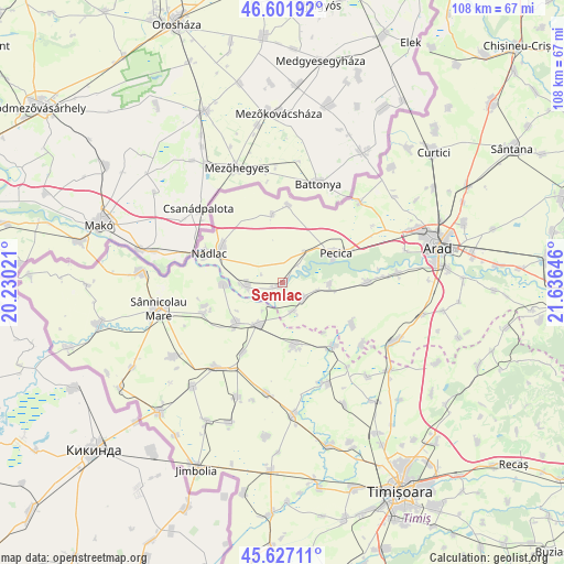
Semlac GPS coordinates[2]
46° 7' 0.012" North, 20° 55' 59.988" East
| Map corner | latitude | longitude |
|---|---|---|
| Upper-left | 46.60192°, | 20.23021° |
| Center: | 46.11667°, | 20.93333° |
| Lower-right: | 45.62711°, | 21.63646° |
| Map W x H: | 108.4×108.4 km | = 67.4×67.4mi |
| max Lat: | 48.23793° ⇑42.3% North |
| Semlac: | 46.11667° |
| min Lat: | ⇓57.7% South 43.65638° |
| min Long | Semlac | max Long |
| 20.31667° | 20.93333° | 29.65403° |
| W 0.6%⇐ | ⇒99.4% E |
Elevation
Elevation of Semlac is 105 m = 344 ft, and this is 149.9 m = 492 ft below average elevation for this country.
| Max E: |
1278 m = 4193 ft | 76.7% |
| Avg. | 254.9 m = 836 ft | |
| Semlac | 105 m = 344 ft | |
Min E: |
-2 m = -7 ft | 23.3% |
See also: Romania elevation on elevation.city.
Geographical zone
Semlac is located in North temperate zone (between Tropic of Cancer and the Arctic Circle). Distance of this North polar circle is 2273.5 km =1412.7 mi to North.| Distance of | km | miles | from Semlac |
|---|---|---|---|
| North Pole | 4879.4 | 3031.9 | to North |
| Arctic Circle | 2273.5 | 1412.7 | to North |
| Tropic Cancer | 2521.8 | 1567 | to South |
| Equator | 5127.7 | 3186.2 | to South |


Nearby cities:
15 places around Semlac: (largest is in red/bold)
• Igriș
11.4 km =7.1 mi,  268°
268°
• Munar
6.8 km =4.2 mi,  102°
102°
• Nădlac
15.2 km =9.4 mi,  291°
291°
• Pecica
11.7 km =7.3 mi,  61°
61°
• Peregu Mare
13.2 km =8.2 mi,  348°
348°
• Peregu Mic
14.9 km =9.3 mi,  4°
4°
• Periam
9 km =5.6 mi,  214°
214°
• Pesac
15.4 km =9.6 mi, 209°
• Satu Mare
5.9 km =3.7 mi,  161°
161°
• Secusigiu
5.3 km =3.3 mi,  133°
133°
• Sânpetru German
8.9 km =5.5 mi,  92°
92°
• Sânpetru Mare
11.9 km =7.4 mi,  228°
228°
• Sânpetru Mic
12.6 km =7.8 mi,  140°
140°
• Variaş
11.2 km =7 mi,  173°
173°
• Şeitin
6.7 km =4.2 mi,  253°
253°
Sources, notices
• [Note1] Compared only with cities in Romania existing in our database
• [Src1] Map data: © OpenStreetMap contributors (CC-BY-SA)
• [Src2] Other city data from geonames.org with taken over terms of usage.
• [Src3] Geographical zone / Annual Mean Temperature by Robert A. Rohde @ Wikipedia
