Pecica geodata
Pecica (Arad) is a seat of a second-order administrative division; located in Romania in Europe/Bucharest (GMT+3) time zone. With population of 12,804 people, there are 150 cities with bigger population in this country. Compared to other cities in Romania, 58.8% of cities are located further ↓South; 99% of cities are located further →East and 78.4% of cities have higher elevation than Pecica. Note1


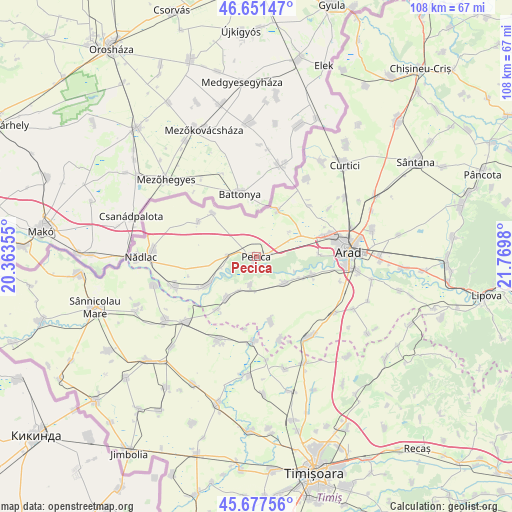
Pecica GPS coordinates[2]
46° 10' 0.012" North, 21° 4' 0.012" East
| Map corner | latitude | longitude |
|---|---|---|
| Upper-left | 46.65147°, | 20.36355° |
| Center: | 46.16667°, | 21.06667° |
| Lower-right: | 45.67756°, | 21.7698° |
| Map W x H: | 108.3×108.3 km | = 67.3×67.3mi |
| max Lat: | 48.23793° ⇑41.2% North |
| Pecica: | 46.16667° |
| min Lat: | ⇓58.8% South 43.65638° |
| min Long | Pecica | max Long |
| 20.31667° | 21.06667° | 29.65403° |
| W 1%⇐ | ⇒99% E |
Elevation
Elevation of Pecica is 100 m = 328 ft, and this is 154.9 m = 508 ft below average elevation for this country.
| Max E: |
1278 m = 4193 ft | 78.4% |
| Avg. | 254.9 m = 836 ft | |
| Pecica | 100 m = 328 ft | |
Min E: |
-2 m = -7 ft | 21.6% |
See also: Romania elevation on elevation.city.
Geographical zone
Pecica is located in North temperate zone (between Tropic of Cancer and the Arctic Circle). Distance of this North polar circle is 2267.9 km =1409.2 mi to North.| Distance of | km | miles | from Pecica |
|---|---|---|---|
| North Pole | 4873.8 | 3028.4 | to North |
| Arctic Circle | 2267.9 | 1409.2 | to North |
| Tropic Cancer | 2527.3 | 1570.4 | to South |
| Equator | 5133.3 | 3189.7 | to South |


Nearby cities:
15 places around Pecica: (largest is in red/bold)
• Felnac
8.5 km =5.3 mi,  130°
130°
• Gelu
17.9 km =11.1 mi,  181°
181°
• Mailat
14.2 km =8.8 mi,  167°
167°
• Munar
7.9 km =4.9 mi,  206°
206°
• Mănăștur
18.2 km =11.3 mi,  163°
163°
• Peregu Mare
14.8 km =9.2 mi,  300°
300°
• Peregu Mic
13 km =8.1 mi,  315°
315°
• Satu Mare
13.9 km =8.6 mi,  216°
216°
• Secusigiu
11.3 km =7 mi, 214°
• Semlac
11.7 km =7.3 mi,  241°
241°
• Sânpetru German
6.1 km =3.8 mi,  192°
192°
• Sânpetru Mic
15.5 km =9.6 mi, 188°
• Turnu
11.1 km =6.9 mi,  24°
24°
• Zădăreni
12.3 km =7.6 mi,  107°
107°
• Şeitin
18.3 km =11.4 mi,  246°
246°
Sources, notices
• [Note1] Compared only with cities in Romania existing in our database
• [Src1] Map data: © OpenStreetMap contributors (CC-BY-SA)
• [Src2] Other city data from geonames.org with taken over terms of usage.
• [Src3] Geographical zone / Annual Mean Temperature by Robert A. Rohde @ Wikipedia
