Schinteiești geodata
Schinteiești (Mehedinţi) is a populated place; located in Romania in Europe/Bucharest (GMT+3) time zone. With population of 536 people, there are 6717 cities with bigger population in this country. Compared to other cities in Romania, 80% of cities are located further ↑North; 88.4% of cities are located further →East and 76.3% of cities have higher elevation than Schinteiești. Note1


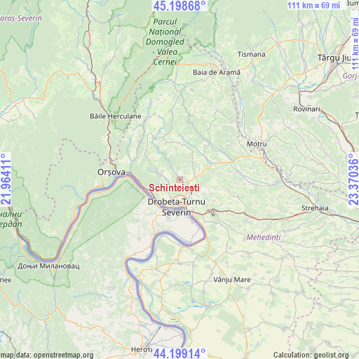
Schinteiești GPS coordinates[2]
44° 42' 3.852" North, 22° 40' 2.028" East
| Map corner | latitude | longitude |
|---|---|---|
| Upper-left | 45.19868°, | 21.96411° |
| Center: | 44.70107°, | 22.66723° |
| Lower-right: | 44.19914°, | 23.37036° |
| Map W x H: | 111.1×111.1 km | = 69×69mi |
| max Lat: | 48.23793° ⇑80% North |
| Schinteiești: | 44.70107° |
| min Lat: | ⇓20% South 43.65638° |
| min Long | Schinteiești | max Long |
| 20.31667° | 22.66723° | 29.65403° |
| W 11.6%⇐ | ⇒88.4% E |
Elevation
Elevation of Schinteiești is 106 m = 348 ft, and this is 148.9 m = 489 ft below average elevation for this country.
| Max E: |
1278 m = 4193 ft | 76.3% |
| Avg. | 254.9 m = 836 ft | |
| Schinteiești | 106 m = 348 ft | |
Min E: |
-2 m = -7 ft | 23.7% |
See also: Romania elevation on elevation.city.
Geographical zone
Schinteiești is located in North temperate zone (between Tropic of Cancer and the Arctic Circle). Distance of this Northern Tropic circle is 2364.4 km =1469.2 mi to South.| Distance of | km | miles | from Schinteiești |
|---|---|---|---|
| North Pole | 5036.8 | 3129.7 | to North |
| Arctic Circle | 2430.9 | 1510.5 | to North |
| Tropic Cancer | 2364.4 | 1469.2 | to South |
| Equator | 4970.3 | 3088.4 | to South |


Nearby cities:
15 places around Schinteiești: (largest is in red/bold)
• Bobaița
7.8 km =4.8 mi,  32°
32°
• Brezniţa Ocol
5.4 km =3.4 mi,  225°
225°
• Cerneți
8.1 km =5 mi,  155°
155°
• Crăguești
10.6 km =6.6 mi,  51°
51°
• Drobeta-Turnu Severin
8.3 km =5.2 mi,  187°
187°
• Dudașu
5.9 km =3.7 mi, 156°
• Dudașu Schelei
8.7 km =5.4 mi,  219°
219°
• Gura Văii
9.5 km =5.9 mi,  246°
246°
• Halânga
2.9 km =1.8 mi,  140°
140°
• Izvoru Bârzii
0.8 km =0.5 mi,  41°
41°
• Jidoștița
6.1 km =3.8 mi,  285°
285°
• Magheru
5.9 km =3.7 mi,  209°
209°
• Malovăţ
5.1 km =3.2 mi,  85°
85°
• Pârlagele
7.4 km =4.6 mi,  14°
14°
• Şimian
10.2 km =6.3 mi, 161°
Sources, notices
• [Note1] Compared only with cities in Romania existing in our database
• [Src1] Map data: © OpenStreetMap contributors (CC-BY-SA)
• [Src2] Other city data from geonames.org with taken over terms of usage.
• [Src3] Geographical zone / Annual Mean Temperature by Robert A. Rohde @ Wikipedia
