Halânga geodata
Halânga (Mehedinţi) is a populated place; located in Romania in Europe/Bucharest (GMT+3) time zone. With population of 1,239 people, there are 3659 cities with bigger population in this country. Compared to other cities in Romania, 80.7% of cities are located further ↑North; 88.2% of cities are located further →East and 83.1% of cities have higher elevation than Halânga. Note1


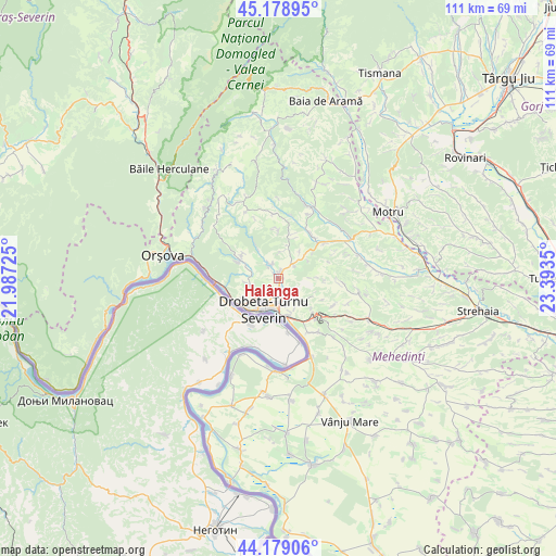
Halânga GPS coordinates[2]
44° 40' 52.176" North, 22° 41' 25.332" East
| Map corner | latitude | longitude |
|---|---|---|
| Upper-left | 45.17895°, | 21.98725° |
| Center: | 44.68116°, | 22.69037° |
| Lower-right: | 44.17906°, | 23.3935° |
| Map W x H: | 111.2×111.2 km | = 69.1×69.1mi |
| max Lat: | 48.23793° ⇑80.7% North |
| Halânga: | 44.68116° |
| min Lat: | ⇓19.3% South 43.65638° |
| min Long | Halânga | max Long |
| 20.31667° | 22.69037° | 29.65403° |
| W 11.8%⇐ | ⇒88.2% E |
Elevation
Elevation of Halânga is 84 m = 276 ft, and this is 170.9 m = 561 ft below average elevation for this country.
| Max E: |
1278 m = 4193 ft | 83.1% |
| Avg. | 254.9 m = 836 ft | |
| Halânga | 84 m = 276 ft | |
Min E: |
-2 m = -7 ft | 16.9% |
See also: Romania elevation on elevation.city.
Geographical zone
Halânga is located in North temperate zone (between Tropic of Cancer and the Arctic Circle). Distance of this Northern Tropic circle is 2362.2 km =1467.8 mi to South.| Distance of | km | miles | from Halânga |
|---|---|---|---|
| North Pole | 5039 | 3131.1 | to North |
| Arctic Circle | 2433.1 | 1511.9 | to North |
| Tropic Cancer | 2362.2 | 1467.8 | to South |
| Equator | 4968.1 | 3087 | to South |


Nearby cities:
15 places around Halânga: (largest is in red/bold)
• Bobaița
9.1 km =5.7 mi,  15°
15°
• Brezniţa Ocol
5.9 km =3.7 mi,  254°
254°
• Cerneți
5.4 km =3.4 mi,  163°
163°
• Crăguești
10.9 km =6.8 mi,  36°
36°
• Drobeta-Turnu Severin
6.7 km =4.2 mi,  206°
206°
• Dudașu
3.2 km =2 mi,  170°
170°
• Dudașu Schelei
8.6 km =5.3 mi,  239°
239°
• Gura Văii
10.7 km =6.6 mi,  261°
261°
• Izvoru Bârzii
3.1 km =1.9 mi,  335°
335°
• Jidoștița
8.6 km =5.3 mi,  296°
296°
• Magheru
5.5 km =3.4 mi, 237°
• Malovăţ
4.1 km =2.5 mi,  51°
51°
• Pârlagele
9.4 km =5.8 mi,  0°
0°
• Schinteiești
2.9 km =1.8 mi,  320°
320°
• Şimian
7.6 km =4.7 mi, 169°
Sources, notices
• [Note1] Compared only with cities in Romania existing in our database
• [Src1] Map data: © OpenStreetMap contributors (CC-BY-SA)
• [Src2] Other city data from geonames.org with taken over terms of usage.
• [Src3] Geographical zone / Annual Mean Temperature by Robert A. Rohde @ Wikipedia
