Scăpău geodata
Scăpău (Mehedinţi) is a populated place; located in Romania in Europe/Bucharest (GMT+3) time zone. With population of 957 people, there are 4430 cities with bigger population in this country. Compared to other cities in Romania, 86.2% of cities are located further ↑North; 87.9% of cities are located further →East and 76.3% of cities have higher elevation than Scăpău. Note1


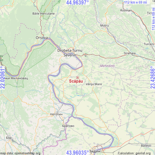
Scăpău GPS coordinates[2]
44° 27' 51.552" North, 22° 43' 25.428" East
| Map corner | latitude | longitude |
|---|---|---|
| Upper-left | 44.96397°, | 22.02061° |
| Center: | 44.46432°, | 22.72373° |
| Lower-right: | 43.96035°, | 23.42686° |
| Map W x H: | 111.6×111.6 km | = 69.3×69.3mi |
| max Lat: | 48.23793° ⇑86.2% North |
| Scăpău: | 44.46432° |
| min Lat: | ⇓13.8% South 43.65638° |
| min Long | Scăpău | max Long |
| 20.31667° | 22.72373° | 29.65403° |
| W 12.1%⇐ | ⇒87.9% E |
Elevation
Elevation of Scăpău is 106 m = 348 ft, and this is 148.9 m = 489 ft below average elevation for this country.
| Max E: |
1278 m = 4193 ft | 76.3% |
| Avg. | 254.9 m = 836 ft | |
| Scăpău | 106 m = 348 ft | |
Min E: |
-2 m = -7 ft | 23.7% |
See also: Romania elevation on elevation.city.
Geographical zone
Scăpău is located in North temperate zone (between Tropic of Cancer and the Arctic Circle). Distance of this Northern Tropic circle is 2338 km =1452.8 mi to South.| Distance of | km | miles | from Scăpău |
|---|---|---|---|
| North Pole | 5063.1 | 3146.1 | to North |
| Arctic Circle | 2457.2 | 1526.8 | to North |
| Tropic Cancer | 2338 | 1452.8 | to South |
| Equator | 4944 | 3072.1 | to South |


Nearby cities:
15 places around Scăpău: (largest is in red/bold)
• Bistrețu
8.6 km =5.3 mi,  257°
257°
• Burila Mare
12 km =7.5 mi, 263°
• Burila Mică
12 km =7.5 mi,  245°
245°
• Cioroboreni
9 km =5.6 mi,  159°
159°
• Devesel
4.5 km =2.8 mi,  276°
276°
• Dănceu
11.1 km =6.9 mi,  181°
181°
• Hinova
9.5 km =5.9 mi,  26°
26°
• Jiana
7 km =4.3 mi,  187°
187°
• Jiana Mare
6.5 km =4 mi,  205°
205°
• Jiana Veche
9.3 km =5.8 mi, 208°
• Livezile
12.3 km =7.6 mi,  64°
64°
• Rogova
6.6 km =4.1 mi,  82°
82°
• Traian
10.6 km =6.6 mi,  92°
92°
• Vânju-Mare
12.4 km =7.7 mi,  110°
110°
• Vânjuleţ
6 km =3.7 mi,  115°
115°
Sources, notices
• [Note1] Compared only with cities in Romania existing in our database
• [Src1] Map data: © OpenStreetMap contributors (CC-BY-SA)
• [Src2] Other city data from geonames.org with taken over terms of usage.
• [Src3] Geographical zone / Annual Mean Temperature by Robert A. Rohde @ Wikipedia
