Săteni geodata
Săteni (Dâmboviţa) is a populated place; located in Romania in Europe/Bucharest (GMT+3) time zone. With population of 1,427 people, there are 3294 cities with bigger population in this country. Compared to other cities in Romania, 70.7% of cities are located further ↑North; 53.2% of cities are located further ←West and 68.4% of cities have lower elevation than Săteni. Note1


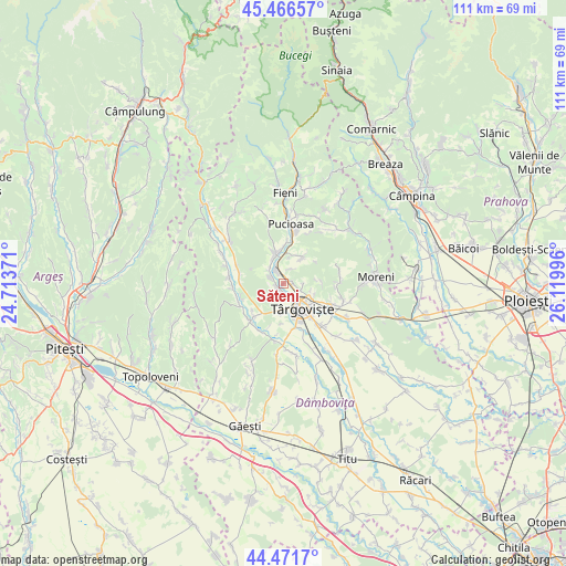
Săteni GPS coordinates[2]
44° 58' 16.644" North, 25° 25' 0.588" East
| Map corner | latitude | longitude |
|---|---|---|
| Upper-left | 45.46657°, | 24.71371° |
| Center: | 44.97129°, | 25.41683° |
| Lower-right: | 44.4717°, | 26.11996° |
| Map W x H: | 110.6×110.6 km | = 68.7×68.7mi |
| max Lat: | 48.23793° ⇑70.7% North |
| Săteni: | 44.97129° |
| min Lat: | ⇓29.3% South 43.65638° |
| min Long | Săteni | max Long |
| 20.31667° | 25.41683° | 29.65403° |
| W 53.2%⇐ | ⇒46.8% E |
Elevation
Elevation of Săteni is 309 m = 1014 ft, and this is 54.1 m = 177 ft above average elevation for this country.
| Max E: |
1278 m = 4193 ft | 31.6% |
| Săteni | 309 m 1014 ft | |
| Avg. | 254.9 m = 836 ft | |
Min E: |
-2 m = -7 ft | 68.4% |
See also: Romania elevation on elevation.city.
Geographical zone
Săteni is located in North temperate zone (between Tropic of Cancer and the Arctic Circle). Distance of this Northern Tropic circle is 2394.4 km =1487.8 mi to South.| Distance of | km | miles | from Săteni |
|---|---|---|---|
| North Pole | 5006.7 | 3111 | to North |
| Arctic Circle | 2400.8 | 1491.8 | to North |
| Tropic Cancer | 2394.4 | 1487.8 | to South |
| Equator | 5000.3 | 3107 | to South |


Nearby cities:
15 places around Săteni: (largest is in red/bold)
• Aninoasa
1.4 km =0.9 mi,  111°
111°
• Doiceşti
1.9 km =1.2 mi,  315°
315°
• Glodeni
6.4 km =4 mi,  37°
37°
• Gura Vulcanei
6.1 km =3.8 mi,  344°
344°
• Gușoiu
5.7 km =3.5 mi,  27°
27°
• Lăculețe
5.4 km =3.4 mi,  12°
12°
• Priboiu
6.2 km =3.9 mi,  4°
4°
• Priseaca
5.4 km =3.4 mi,  191°
191°
• Teiș
1.4 km =0.9 mi,  229°
229°
• Toculești
6.8 km =4.2 mi,  346°
346°
• Târgovişte
6 km =3.7 mi,  148°
148°
• Valea Voievozilor
6.5 km =4 mi,  124°
124°
• Viforâta
3.5 km =2.2 mi, 111°
• Vulcana-Pandele
5.3 km =3.3 mi, 339°
• Şotânga
4.2 km =2.6 mi,  288°
288°
Sources, notices
• [Note1] Compared only with cities in Romania existing in our database
• [Src1] Map data: © OpenStreetMap contributors (CC-BY-SA)
• [Src2] Other city data from geonames.org with taken over terms of usage.
• [Src3] Geographical zone / Annual Mean Temperature by Robert A. Rohde @ Wikipedia
