Târgovişte geodata
Târgovişte (Dâmboviţa) is a seat of a first-order administrative division; located in Romania in Europe/Bucharest (GMT+3) time zone. With population of 88,435 people, there are 32 cities with bigger population in this country. Compared to other cities in Romania, 72.3% of cities are located further ↑North; 54% of cities are located further ←West and 63.8% of cities have lower elevation than Târgovişte. Note1


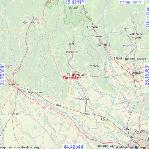
Târgovişte GPS coordinates[2]
44° 55' 31.548" North, 25° 27' 24.12" East
| Map corner | latitude | longitude |
|---|---|---|
| Upper-left | 45.4211°, | 24.75358° |
| Center: | 44.92543°, | 25.4567° |
| Lower-right: | 44.42544°, | 26.15983° |
| Map W x H: | 110.7×110.7 km | = 68.8×68.8mi |
| max Lat: | 48.23793° ⇑72.3% North |
| Târgovişte: | 44.92543° |
| min Lat: | ⇓27.7% South 43.65638° |
| min Long | Târgovişte | max Long |
| 20.31667° | 25.4567° | 29.65403° |
| W 54%⇐ | ⇒46% E |
Elevation
Elevation of Târgovişte is 283 m = 928 ft, and this is 28.1 m = 92 ft above average elevation for this country.
| Max E: |
1278 m = 4193 ft | 36.2% |
| Târgovişte | 283 m 928 ft | |
| Avg. | 254.9 m = 836 ft | |
Min E: |
-2 m = -7 ft | 63.8% |
See also: Târgovişte elevation on elevation.city.
Geographical zone
Târgovişte is located in North temperate zone (between Tropic of Cancer and the Arctic Circle). Distance of this Northern Tropic circle is 2389.3 km =1484.6 mi to South.| Distance of | km | miles | from Târgovişte |
|---|---|---|---|
| North Pole | 5011.8 | 3114.2 | to North |
| Arctic Circle | 2405.9 | 1495 | to North |
| Tropic Cancer | 2389.3 | 1484.6 | to South |
| Equator | 4995.2 | 3103.9 | to South |


Nearby cities:
15 places around Târgovişte: (largest is in red/bold)
• Aninoasa
4.9 km =3 mi,  338°
338°
• Doiceşti
7.8 km =4.8 mi,  325°
325°
• Gorgota
7 km =4.3 mi,  35°
35°
• Mogoșești
6.7 km =4.2 mi,  223°
223°
• Ochiuri
8.2 km =5.1 mi,  59°
59°
• Priseaca
4.2 km =2.6 mi,  267°
267°
• Răzvad
6.1 km =3.8 mi,  81°
81°
• Săteni
6 km =3.7 mi, 328°
• Teiș
5.9 km =3.7 mi,  314°
314°
• Ulmi
4.4 km =2.7 mi,  129°
129°
• Ungureni
7.9 km =4.9 mi, 220°
• Valea Voievozilor
2.6 km =1.6 mi, 57°
• Viforâta
3.9 km =2.4 mi,  1°
1°
• Viișoara
5.4 km =3.4 mi,  205°
205°
• Văcăreşti
8.6 km =5.3 mi,  165°
165°
Sources, notices
• [Note1] Compared only with cities in Romania existing in our database
• [Src1] Map data: © OpenStreetMap contributors (CC-BY-SA)
• [Src2] Other city data from geonames.org with taken over terms of usage.
• [Src3] Geographical zone / Annual Mean Temperature by Robert A. Rohde @ Wikipedia
