Lăculețe geodata
Lăculețe (Dâmboviţa) is a populated place; located in Romania in Europe/Bucharest (GMT+3) time zone. With population of 1,010 people, there are 4261 cities with bigger population in this country. Compared to other cities in Romania, 69% of cities are located further ↑North; 53.4% of cities are located further ←West and 75.4% of cities have lower elevation than Lăculețe. Note1


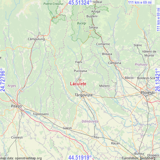
Lăculețe GPS coordinates[2]
45° 1' 6.132" North, 25° 25' 51.888" East
| Map corner | latitude | longitude |
|---|---|---|
| Upper-left | 45.51324°, | 24.72796° |
| Center: | 45.01837°, | 25.43108° |
| Lower-right: | 44.51919°, | 26.13421° |
| Map W x H: | 110.5×110.5 km | = 68.7×68.7mi |
| max Lat: | 48.23793° ⇑69% North |
| Lăculețe: | 45.01837° |
| min Lat: | ⇓31% South 43.65638° |
| min Long | Lăculețe | max Long |
| 20.31667° | 25.43108° | 29.65403° |
| W 53.4%⇐ | ⇒46.6% E |
Elevation
Elevation of Lăculețe is 356 m = 1168 ft, and this is 101.1 m = 332 ft above average elevation for this country.
| Max E: |
1278 m = 4193 ft | 24.6% |
| Lăculețe | 356 m 1168 ft | |
| Avg. | 254.9 m = 836 ft | |
Min E: |
-2 m = -7 ft | 75.4% |
See also: Romania elevation on elevation.city.
Geographical zone
Lăculețe is located in North temperate zone (between Tropic of Cancer and the Arctic Circle). Distance of this North polar circle is 2395.6 km =1488.6 mi to North.| Distance of | km | miles | from Lăculețe |
|---|---|---|---|
| North Pole | 5001.5 | 3107.8 | to North |
| Arctic Circle | 2395.6 | 1488.6 | to North |
| Tropic Cancer | 2399.7 | 1491.1 | to South |
| Equator | 5005.6 | 3110.3 | to South |


Nearby cities:
15 places around Lăculețe: (largest is in red/bold)
• Aninoasa
5.8 km =3.6 mi,  178°
178°
• Brăneşti
2 km =1.2 mi,  325°
325°
• Doiceşti
4.6 km =2.9 mi,  212°
212°
• Glodeni
2.8 km =1.7 mi,  93°
93°
• Glodeni
5.3 km =3.3 mi,  19°
19°
• Gura Vulcanei
2.8 km =1.7 mi,  283°
283°
• Gușoiu
1.5 km =0.9 mi,  97°
97°
• Priboiu
1.1 km =0.7 mi,  324°
324°
• Pucioasa
6.6 km =4.1 mi,  0°
0°
• Schela
3.7 km =2.3 mi,  69°
69°
• Săteni
5.4 km =3.4 mi,  192°
192°
• Teiș
6.6 km =4.1 mi,  199°
199°
• Toculești
3 km =1.9 mi,  296°
296°
• Vulcana-Pandele
3 km =1.9 mi,  264°
264°
• Şotânga
6.4 km =4 mi,  232°
232°
Sources, notices
• [Note1] Compared only with cities in Romania existing in our database
• [Src1] Map data: © OpenStreetMap contributors (CC-BY-SA)
• [Src2] Other city data from geonames.org with taken over terms of usage.
• [Src3] Geographical zone / Annual Mean Temperature by Robert A. Rohde @ Wikipedia
