Sările geodata
Sările (Buzău) is a populated place; located in Romania in Europe/Bucharest (GMT+3) time zone. With population of 586 people, there are 6316 cities with bigger population in this country. Compared to other cities in Romania, 54.6% of cities are located further ↑North; 77.7% of cities are located further ←West and 93.8% of cities have lower elevation than Sările. Note1


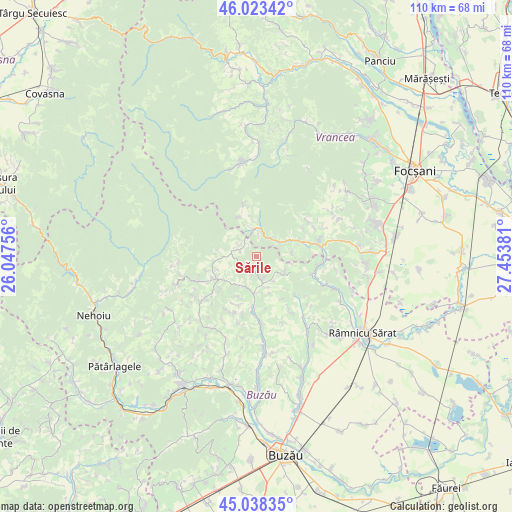
Sările GPS coordinates[2]
45° 31' 58.944" North, 26° 45' 2.448" East
| Map corner | latitude | longitude |
|---|---|---|
| Upper-left | 46.02342°, | 26.04756° |
| Center: | 45.53304°, | 26.75068° |
| Lower-right: | 45.03835°, | 27.45381° |
| Map W x H: | 109.5×109.5 km | = 68×68mi |
| max Lat: | 48.23793° ⇑54.6% North |
| Sările: | 45.53304° |
| min Lat: | ⇓45.4% South 43.65638° |
| min Long | Sările | max Long |
| 20.31667° | 26.75068° | 29.65403° |
| W 77.7%⇐ | ⇒22.3% E |
Elevation
Elevation of Sările is 590 m = 1936 ft, and this is 335.1 m = 1099 ft above average elevation for this country.
| Max E: |
1278 m = 4193 ft | 6.2% |
| Sările | 590 m 1936 ft | |
| Avg. | 254.9 m = 836 ft | |
Min E: |
-2 m = -7 ft | 93.8% |
See also: Romania elevation on elevation.city.
Geographical zone
Sările is located in North temperate zone (between Tropic of Cancer and the Arctic Circle). Distance of this North polar circle is 2338.4 km =1453 mi to North.| Distance of | km | miles | from Sările |
|---|---|---|---|
| North Pole | 4944.3 | 3072.2 | to North |
| Arctic Circle | 2338.4 | 1453 | to North |
| Tropic Cancer | 2456.9 | 1526.6 | to South |
| Equator | 5062.8 | 3145.9 | to South |


Nearby cities:
15 places around Sările: (largest is in red/bold)
• Bahnele
12.1 km =7.5 mi,  349°
349°
• Bisoca
3.9 km =2.4 mi,  270°
270°
• Chiojdeni
9.2 km =5.7 mi,  78°
78°
• Grunji
8.7 km =5.4 mi,  244°
244°
• Hârja
6.3 km =3.9 mi,  125°
125°
• Jitia
6.2 km =3.9 mi,  334°
334°
• Luncile
5.8 km =3.6 mi,  58°
58°
• Mânzăleşti
8.7 km =5.4 mi, 244°
• Neculele
10.8 km =6.7 mi,  344°
344°
• Niculești
10.8 km =6.7 mi,  183°
183°
• Pleși
7.2 km =4.5 mi,  315°
315°
• Săruleşti
3.7 km =2.3 mi, 180°
• Valea Salciei
7 km =4.3 mi, 125°
• Vintileasca
7.6 km =4.7 mi, 349°
• Vintilă Vodă
7.8 km =4.8 mi,  199°
199°
Sources, notices
• [Note1] Compared only with cities in Romania existing in our database
• [Src1] Map data: © OpenStreetMap contributors (CC-BY-SA)
• [Src2] Other city data from geonames.org with taken over terms of usage.
• [Src3] Geographical zone / Annual Mean Temperature by Robert A. Rohde @ Wikipedia
