Santău geodata
Santău (Satu Mare) is a seat of a second-order administrative division; located in Romania in Europe/Bucharest (GMT+3) time zone. With population of 2,580 people, there are 2084 cities with bigger population in this country. Compared to other cities in Romania, 91.2% of cities are located further ↓South; 89.6% of cities are located further →East and 71.2% of cities have higher elevation than Santău. Note1


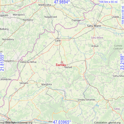
Santău GPS coordinates[2]
47° 31' 0.012" North, 22° 31' 0.012" East
| Map corner | latitude | longitude |
|---|---|---|
| Upper-left | 47.9894°, | 21.81355° |
| Center: | 47.51667°, | 22.51667° |
| Lower-right: | 47.03965°, | 23.2198° |
| Map W x H: | 105.6×105.6 km | = 65.6×65.6mi |
| max Lat: | 48.23793° ⇑8.8% North |
| Santău: | 47.51667° |
| min Lat: | ⇓91.2% South 43.65638° |
| min Long | Santău | max Long |
| 20.31667° | 22.51667° | 29.65403° |
| W 10.4%⇐ | ⇒89.6% E |
Elevation
Elevation of Santău is 123 m = 404 ft, and this is 131.9 m = 433 ft below average elevation for this country.
| Max E: |
1278 m = 4193 ft | 71.2% |
| Avg. | 254.9 m = 836 ft | |
| Santău | 123 m = 404 ft | |
Min E: |
-2 m = -7 ft | 28.8% |
See also: Romania elevation on elevation.city.
Geographical zone
Santău is located in North temperate zone (between Tropic of Cancer and the Arctic Circle). Distance of this North polar circle is 2117.8 km =1315.9 mi to North.| Distance of | km | miles | from Santău |
|---|---|---|---|
| North Pole | 4723.7 | 2935.2 | to North |
| Arctic Circle | 2117.8 | 1315.9 | to North |
| Tropic Cancer | 2677.4 | 1663.7 | to South |
| Equator | 5283.4 | 3283 | to South |


Nearby cities:
15 places around Santău: (largest is in red/bold)
• Andrid
12.5 km =7.8 mi,  270°
270°
• Becheni
8.8 km =5.5 mi,  215°
215°
• Cehăluț
10.7 km =6.6 mi,  159°
159°
• Chereușa
5.6 km =3.5 mi,  240°
240°
• Cig
9.3 km =5.8 mi,  81°
81°
• Căuaş
6.1 km =3.8 mi,  24°
24°
• Dindești
10.3 km =6.4 mi,  280°
280°
• Irina
9.4 km =5.8 mi,  295°
295°
• Pir
12.6 km =7.8 mi, 243°
• Păgaia
12.2 km =7.6 mi,  185°
185°
• Sărăuad
9.2 km =5.7 mi,  116°
116°
• Săuca
6.1 km =3.8 mi,  204°
204°
• Tiream
11.7 km =7.3 mi,  341°
341°
• Tăşnad
6.2 km =3.9 mi,  126°
126°
• Vezendiu
9 km =5.6 mi,  315°
315°
Sources, notices
• [Note1] Compared only with cities in Romania existing in our database
• [Src1] Map data: © OpenStreetMap contributors (CC-BY-SA)
• [Src2] Other city data from geonames.org with taken over terms of usage.
• [Src3] Geographical zone / Annual Mean Temperature by Robert A. Rohde @ Wikipedia
