Păgaia geodata
Păgaia (Bihor) is a populated place; located in Romania in Europe/Bucharest (GMT+3) time zone. With population of 742 people, there are 5333 cities with bigger population in this country. Compared to other cities in Romania, 89% of cities are located further ↓South; 89.7% of cities are located further →East and 60.6% of cities have higher elevation than Păgaia. Note1


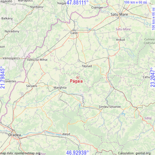
Păgaia GPS coordinates[2]
47° 24' 26.64" North, 22° 30' 5.652" East
| Map corner | latitude | longitude |
|---|---|---|
| Upper-left | 47.88111°, | 21.79845° |
| Center: | 47.4074°, | 22.50157° |
| Lower-right: | 46.92939°, | 23.2047° |
| Map W x H: | 105.8×105.8 km | = 65.7×65.7mi |
| max Lat: | 48.23793° ⇑11% North |
| Păgaia: | 47.4074° |
| min Lat: | ⇓89% South 43.65638° |
| min Long | Păgaia | max Long |
| 20.31667° | 22.50157° | 29.65403° |
| W 10.3%⇐ | ⇒89.7% E |
Elevation
Elevation of Păgaia is 164 m = 538 ft, and this is 90.9 m = 298 ft below average elevation for this country.
| Max E: |
1278 m = 4193 ft | 60.6% |
| Avg. | 254.9 m = 836 ft | |
| Păgaia | 164 m = 538 ft | |
Min E: |
-2 m = -7 ft | 39.4% |
See also: Romania elevation on elevation.city.
Geographical zone
Păgaia is located in North temperate zone (between Tropic of Cancer and the Arctic Circle). Distance of this North polar circle is 2130 km =1323.5 mi to North.| Distance of | km | miles | from Păgaia |
|---|---|---|---|
| North Pole | 4735.9 | 2942.8 | to North |
| Arctic Circle | 2130 | 1323.5 | to North |
| Tropic Cancer | 2665.3 | 1656.1 | to South |
| Equator | 5271.2 | 3275.4 | to South |


Nearby cities:
15 places around Păgaia: (largest is in red/bold)
• Almașu Mare
9.1 km =5.7 mi,  165°
165°
• Almașu Mic
10 km =6.2 mi,  176°
176°
• Becheni
6.4 km =4 mi,  321°
321°
• Boianu Mare
3.6 km =2.2 mi,  138°
138°
• Cehal
7.9 km =4.9 mi,  109°
109°
• Cehăluț
5.3 km =3.3 mi,  66°
66°
• Chereușa
10.1 km =6.3 mi,  338°
338°
• Ghenetea
8.1 km =5 mi,  255°
255°
• Pir
12.1 km =7.5 mi,  303°
303°
• Santău
12.2 km =7.6 mi,  5°
5°
• Suiug
11 km =6.8 mi,  208°
208°
• Săldăbagiu de Barcău
12.2 km =7.6 mi,  193°
193°
• Săuca
6.7 km =4.2 mi,  348°
348°
• Tăşnad
10.4 km =6.5 mi,  36°
36°
• Viişoara
4.7 km =2.9 mi,  235°
235°
Sources, notices
• [Note1] Compared only with cities in Romania existing in our database
• [Src1] Map data: © OpenStreetMap contributors (CC-BY-SA)
• [Src2] Other city data from geonames.org with taken over terms of usage.
• [Src3] Geographical zone / Annual Mean Temperature by Robert A. Rohde @ Wikipedia
