Tăşnad geodata
Tăşnad (Satu Mare) is a seat of a second-order administrative division; located in Romania in Europe/Bucharest (GMT+3) time zone. With population of 9,466 people, there are 240 cities with bigger population in this country. Compared to other cities in Romania, 90.6% of cities are located further ↓South; 89.1% of cities are located further →East and 57.3% of cities have higher elevation than Tăşnad. Note1


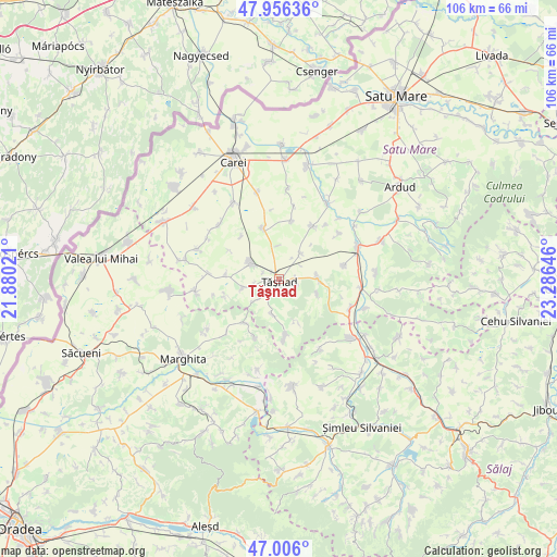
Tăşnad GPS coordinates[2]
47° 28' 59.988" North, 22° 34' 59.988" East
| Map corner | latitude | longitude |
|---|---|---|
| Upper-left | 47.95636°, | 21.88021° |
| Center: | 47.48333°, | 22.58333° |
| Lower-right: | 47.006°, | 23.28646° |
| Map W x H: | 105.7×105.7 km | = 65.7×65.7mi |
| max Lat: | 48.23793° ⇑9.4% North |
| Tăşnad: | 47.48333° |
| min Lat: | ⇓90.6% South 43.65638° |
| min Long | Tăşnad | max Long |
| 20.31667° | 22.58333° | 29.65403° |
| W 10.9%⇐ | ⇒89.1% E |
Elevation
Elevation of Tăşnad is 177 m = 581 ft, and this is 77.9 m = 256 ft below average elevation for this country.
| Max E: |
1278 m = 4193 ft | 57.3% |
| Avg. | 254.9 m = 836 ft | |
| Tăşnad | 177 m = 581 ft | |
Min E: |
-2 m = -7 ft | 42.7% |
See also: Romania elevation on elevation.city.
Geographical zone
Tăşnad is located in North temperate zone (between Tropic of Cancer and the Arctic Circle). Distance of this North polar circle is 2121.5 km =1318.2 mi to North.| Distance of | km | miles | from Tăşnad |
|---|---|---|---|
| North Pole | 4727.4 | 2937.5 | to North |
| Arctic Circle | 2121.5 | 1318.2 | to North |
| Tropic Cancer | 2673.7 | 1661.4 | to South |
| Equator | 5279.7 | 3280.7 | to South |


Nearby cities:
15 places around Tăşnad: (largest is in red/bold)
• Becheni
10.7 km =6.6 mi,  251°
251°
• Boianu Mare
11.7 km =7.3 mi,  198°
198°
• Cehal
11.2 km =7 mi,  173°
173°
• Cehăluț
6.5 km =4 mi,  191°
191°
• Chereușa
10 km =6.2 mi,  275°
275°
• Cig
6.6 km =4.1 mi,  40°
40°
• Căuaş
9.6 km =6 mi,  344°
344°
• Eriu-Sâncrai
12.8 km =8 mi,  29°
29°
• Mihăieni
14.5 km =9 mi,  52°
52°
• Păgaia
10.4 km =6.5 mi,  216°
216°
• Santău
6.2 km =3.9 mi,  306°
306°
• Săcăşeni
7.5 km =4.7 mi,  90°
90°
• Sărăuad
3.2 km =2 mi,  97°
97°
• Săuca
7.7 km =4.8 mi,  256°
256°
• Unimăt
12.4 km =7.7 mi,  78°
78°
Sources, notices
• [Note1] Compared only with cities in Romania existing in our database
• [Src1] Map data: © OpenStreetMap contributors (CC-BY-SA)
• [Src2] Other city data from geonames.org with taken over terms of usage.
• [Src3] Geographical zone / Annual Mean Temperature by Robert A. Rohde @ Wikipedia
