Sălișca geodata
Sălișca (Cluj) is a populated place; located in Romania in Europe/Bucharest (GMT+3) time zone. With population of 593 people, there are 6250 cities with bigger population in this country. Compared to other cities in Romania, 84.5% of cities are located further ↓South; 72.2% of cities are located further →East and 58.6% of cities have lower elevation than Sălișca. Note1


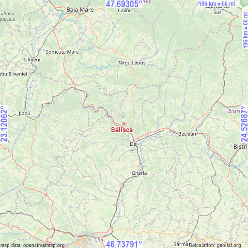
Sălișca GPS coordinates[2]
47° 13' 3.468" North, 23° 49' 25.464" East
| Map corner | latitude | longitude |
|---|---|---|
| Upper-left | 47.69305°, | 23.12062° |
| Center: | 47.21763°, | 23.82374° |
| Lower-right: | 46.73791°, | 24.52687° |
| Map W x H: | 106.2×106.2 km | = 66×66mi |
| max Lat: | 48.23793° ⇑15.5% North |
| Sălișca: | 47.21763° |
| min Lat: | ⇓84.5% South 43.65638° |
| min Long | Sălișca | max Long |
| 20.31667° | 23.82374° | 29.65403° |
| W 27.8%⇐ | ⇒72.2% E |
Elevation
Elevation of Sălișca is 255 m = 837 ft, and this is 0.099999999999994 m = 0 ft above average elevation for this country.
| Max E: |
1278 m = 4193 ft | 41.4% |
| Sălișca | 255 m 837 ft | |
| Avg. | 254.9 m = 836 ft | |
Min E: |
-2 m = -7 ft | 58.6% |
See also: Romania elevation on elevation.city.
Geographical zone
Sălișca is located in North temperate zone (between Tropic of Cancer and the Arctic Circle). Distance of this North polar circle is 2151.1 km =1336.6 mi to North.| Distance of | km | miles | from Sălișca |
|---|---|---|---|
| North Pole | 4757 | 2955.9 | to North |
| Arctic Circle | 2151.1 | 1336.6 | to North |
| Tropic Cancer | 2644.2 | 1643 | to South |
| Equator | 5250.1 | 3262.3 | to South |


Nearby cities:
15 places around Sălișca: (largest is in red/bold)
• Cetan
3.2 km =2 mi,  209°
209°
• Chiuiești
9.6 km =6 mi,  23°
23°
• Cuzdrioara
9 km =5.6 mi,  128°
128°
• Câţcău
3.6 km =2.2 mi,  237°
237°
• Căşeiu
5 km =3.1 mi,  139°
139°
• Dej
8.2 km =5.1 mi,  156°
156°
• Gâlgău
11.7 km =7.3 mi,  307°
307°
• Jichişu de Jos
11.4 km =7.1 mi,  189°
189°
• Mănășturel
11 km =6.8 mi,  117°
117°
• Ocna Dejului
11.6 km =7.2 mi,  166°
166°
• Poiana Blenchii
10.7 km =6.6 mi,  328°
328°
• Rugășești
4 km =2.5 mi,  67°
67°
• Urișor
6.8 km =4.2 mi, 142°
• Vad
5.9 km =3.7 mi,  250°
250°
• Șomcutu Mic
7.7 km =4.8 mi,  216°
216°
Sources, notices
• [Note1] Compared only with cities in Romania existing in our database
• [Src1] Map data: © OpenStreetMap contributors (CC-BY-SA)
• [Src2] Other city data from geonames.org with taken over terms of usage.
• [Src3] Geographical zone / Annual Mean Temperature by Robert A. Rohde @ Wikipedia
