Rugășești geodata
Rugășești (Cluj) is a populated place; located in Romania in Europe/Bucharest (GMT+3) time zone. With population of 1,086 people, there are 4028 cities with bigger population in this country. Compared to other cities in Romania, 84.8% of cities are located further ↓South; 71.4% of cities are located further →East and 59.9% of cities have lower elevation than Rugășești. Note1


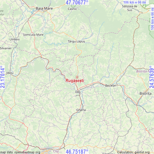
Rugășești GPS coordinates[2]
47° 13' 53.292" North, 23° 52' 23.736" East
| Map corner | latitude | longitude |
|---|---|---|
| Upper-left | 47.70677°, | 23.17014° |
| Center: | 47.23147°, | 23.87326° |
| Lower-right: | 46.75187°, | 24.57639° |
| Map W x H: | 106.2×106.2 km | = 66×66mi |
| max Lat: | 48.23793° ⇑15.2% North |
| Rugășești: | 47.23147° |
| min Lat: | ⇓84.8% South 43.65638° |
| min Long | Rugășești | max Long |
| 20.31667° | 23.87326° | 29.65403° |
| W 28.6%⇐ | ⇒71.4% E |
Elevation
Elevation of Rugășești is 262 m = 860 ft, and this is 7.1 m = 23 ft above average elevation for this country.
| Max E: |
1278 m = 4193 ft | 40.1% |
| Rugășești | 262 m 860 ft | |
| Avg. | 254.9 m = 836 ft | |
Min E: |
-2 m = -7 ft | 59.9% |
See also: Romania elevation on elevation.city.
Geographical zone
Rugășești is located in North temperate zone (between Tropic of Cancer and the Arctic Circle). Distance of this North polar circle is 2149.5 km =1335.6 mi to North.| Distance of | km | miles | from Rugășești |
|---|---|---|---|
| North Pole | 4755.4 | 2954.9 | to North |
| Arctic Circle | 2149.5 | 1335.6 | to North |
| Tropic Cancer | 2645.7 | 1644 | to South |
| Equator | 5251.6 | 3263.2 | to South |


Nearby cities:
15 places around Rugășești: (largest is in red/bold)
• Bața
10.4 km =6.5 mi,  117°
117°
• Cetan
6.8 km =4.2 mi,  231°
231°
• Chiuiești
7.3 km =4.5 mi,  1°
1°
• Ciceu-Giurgeşti
11 km =6.8 mi,  79°
79°
• Ciceu-Mihăiești
9.2 km =5.7 mi, 123°
• Cuzdrioara
7.9 km =4.9 mi,  155°
155°
• Câţcău
7.6 km =4.7 mi,  242°
242°
• Căşeiu
5.4 km =3.4 mi,  185°
185°
• Dej
9.1 km =5.7 mi,  183°
183°
• Dumbrăveni
10.5 km =6.5 mi,  56°
56°
• Mănășturel
9 km =5.6 mi,  138°
138°
• Sălișca
4 km =2.5 mi,  247°
247°
• Urișor
7 km =4.3 mi, 177°
• Vad
9.9 km =6.2 mi, 249°
• Șomcutu Mic
11.3 km =7 mi, 227°
Sources, notices
• [Note1] Compared only with cities in Romania existing in our database
• [Src1] Map data: © OpenStreetMap contributors (CC-BY-SA)
• [Src2] Other city data from geonames.org with taken over terms of usage.
• [Src3] Geographical zone / Annual Mean Temperature by Robert A. Rohde @ Wikipedia
