Rudeni geodata
Rudeni (Arges) is a populated place; located in Romania in Europe/Bucharest (GMT+3) time zone. With population of 581 people, there are 6349 cities with bigger population in this country. Compared to other cities in Romania, 64.4% of cities are located further ↑North; 52.5% of cities are located further →East and 84.1% of cities have lower elevation than Rudeni. Note1


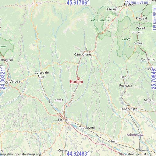
Rudeni GPS coordinates[2]
45° 7' 23.16" North, 25° 0' 22.788" East
| Map corner | latitude | longitude |
|---|---|---|
| Upper-left | 45.61706°, | 24.30321° |
| Center: | 45.1231°, | 25.00633° |
| Lower-right: | 44.62483°, | 25.70946° |
| Map W x H: | 110.3×110.3 km | = 68.5×68.5mi |
| max Lat: | 48.23793° ⇑64.4% North |
| Rudeni: | 45.1231° |
| min Lat: | ⇓35.6% South 43.65638° |
| min Long | Rudeni | max Long |
| 20.31667° | 25.00633° | 29.65403° |
| W 47.5%⇐ | ⇒52.5% E |
Elevation
Elevation of Rudeni is 436 m = 1430 ft, and this is 181.1 m = 594 ft above average elevation for this country.
| Max E: |
1278 m = 4193 ft | 15.9% |
| Rudeni | 436 m 1430 ft | |
| Avg. | 254.9 m = 836 ft | |
Min E: |
-2 m = -7 ft | 84.1% |
See also: Romania elevation on elevation.city.
Geographical zone
Rudeni is located in North temperate zone (between Tropic of Cancer and the Arctic Circle). Distance of this North polar circle is 2384 km =1481.3 mi to North.| Distance of | km | miles | from Rudeni |
|---|---|---|---|
| North Pole | 4989.8 | 3100.5 | to North |
| Arctic Circle | 2384 | 1481.3 | to North |
| Tropic Cancer | 2411.3 | 1498.3 | to South |
| Equator | 5017.2 | 3117.5 | to South |


Nearby cities:
15 places around Rudeni: (largest is in red/bold)
• Bălileşti
8.5 km =5.3 mi,  222°
222°
• Capu Piscului
6.7 km =4.2 mi,  339°
339°
• Cotești
8.6 km =5.3 mi, 343°
• Drăghici
3.1 km =1.9 mi,  78°
78°
• Furnicoși
2.2 km =1.4 mi,  351°
351°
• Hârtieşti
7.4 km =4.6 mi,  95°
95°
• Lăzărești
3.8 km =2.4 mi, 347°
• Mihăeşti
0.9 km =0.6 mi,  214°
214°
• Poienița
6.3 km =3.9 mi,  258°
258°
• Rădești
5.7 km =3.5 mi,  183°
183°
• Valea Mare-Bratia
7.1 km =4.4 mi, 217°
• Valea Pechii
7.5 km =4.7 mi,  3°
3°
• Valea Popii
3.6 km =2.2 mi,  159°
159°
• Vlădești
7.6 km =4.7 mi,  293°
293°
• Văcarea
3.5 km =2.2 mi,  107°
107°
Sources, notices
• [Note1] Compared only with cities in Romania existing in our database
• [Src1] Map data: © OpenStreetMap contributors (CC-BY-SA)
• [Src2] Other city data from geonames.org with taken over terms of usage.
• [Src3] Geographical zone / Annual Mean Temperature by Robert A. Rohde @ Wikipedia
