Drăghici geodata
Drăghici (Arges) is a populated place; located in Romania in Europe/Bucharest (GMT+3) time zone. With population of 1,184 people, there are 3782 cities with bigger population in this country. Compared to other cities in Romania, 64.3% of cities are located further ↑North; 52% of cities are located further →East and 85.1% of cities have lower elevation than Drăghici. Note1


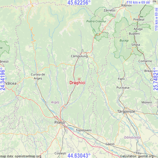
Drăghici GPS coordinates[2]
45° 7' 43.14" North, 25° 2' 42.288" East
| Map corner | latitude | longitude |
|---|---|---|
| Upper-left | 45.62256°, | 24.34196° |
| Center: | 45.12865°, | 25.04508° |
| Lower-right: | 44.63043°, | 25.74821° |
| Map W x H: | 110.3×110.3 km | = 68.5×68.5mi |
| max Lat: | 48.23793° ⇑64.3% North |
| Drăghici: | 45.12865° |
| min Lat: | ⇓35.7% South 43.65638° |
| min Long | Drăghici | max Long |
| 20.31667° | 25.04508° | 29.65403° |
| W 48%⇐ | ⇒52% E |
Elevation
Elevation of Drăghici is 446 m = 1463 ft, and this is 191.1 m = 627 ft above average elevation for this country.
| Max E: |
1278 m = 4193 ft | 14.9% |
| Drăghici | 446 m 1463 ft | |
| Avg. | 254.9 m = 836 ft | |
Min E: |
-2 m = -7 ft | 85.1% |
See also: Romania elevation on elevation.city.
Geographical zone
Drăghici is located in North temperate zone (between Tropic of Cancer and the Arctic Circle). Distance of this North polar circle is 2383.3 km =1480.9 mi to North.| Distance of | km | miles | from Drăghici |
|---|---|---|---|
| North Pole | 4989.2 | 3100.1 | to North |
| Arctic Circle | 2383.3 | 1480.9 | to North |
| Tropic Cancer | 2411.9 | 1498.7 | to South |
| Equator | 5017.8 | 3117.9 | to South |


Nearby cities:
15 places around Drăghici: (largest is in red/bold)
• Boteni
8.3 km =5.2 mi,  42°
42°
• Capu Piscului
7.8 km =4.8 mi,  316°
316°
• Furnicoși
3.7 km =2.3 mi,  295°
295°
• Hârtieşti
4.5 km =2.8 mi,  107°
107°
• Jugur
7.8 km =4.8 mi,  23°
23°
• Lunca
8 km =5 mi,  52°
52°
• Lăzărești
5 km =3.1 mi,  308°
308°
• Mihăeşti
3.8 km =2.4 mi,  249°
249°
• Rudeni
3.1 km =1.9 mi,  258°
258°
• Rădești
7.2 km =4.5 mi,  208°
208°
• Schitu-Goleşti
8.7 km =5.4 mi,  335°
335°
• Valea Pechii
7.3 km =4.5 mi, 339°
• Valea Popii
4.4 km =2.7 mi,  203°
203°
• Vulturești
7.6 km =4.7 mi,  156°
156°
• Văcarea
1.7 km =1.1 mi,  168°
168°
Sources, notices
• [Note1] Compared only with cities in Romania existing in our database
• [Src1] Map data: © OpenStreetMap contributors (CC-BY-SA)
• [Src2] Other city data from geonames.org with taken over terms of usage.
• [Src3] Geographical zone / Annual Mean Temperature by Robert A. Rohde @ Wikipedia
