Furnicoși geodata
Furnicoși (Arges) is a populated place; located in Romania in Europe/Bucharest (GMT+3) time zone. With population of 802 people, there are 5037 cities with bigger population in this country. Compared to other cities in Romania, 63.7% of cities are located further ↑North; 52.5% of cities are located further →East and 86.4% of cities have lower elevation than Furnicoși. Note1


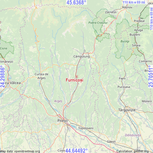
Furnicoși GPS coordinates[2]
45° 8' 34.872" North, 25° 0' 7.128" East
| Map corner | latitude | longitude |
|---|---|---|
| Upper-left | 45.6368°, | 24.29886° |
| Center: | 45.14302°, | 25.00198° |
| Lower-right: | 44.64492°, | 25.70511° |
| Map W x H: | 110.3×110.3 km | = 68.5×68.5mi |
| max Lat: | 48.23793° ⇑63.7% North |
| Furnicoși: | 45.14302° |
| min Lat: | ⇓36.3% South 43.65638° |
| min Long | Furnicoși | max Long |
| 20.31667° | 25.00198° | 29.65403° |
| W 47.5%⇐ | ⇒52.5% E |
Elevation
Elevation of Furnicoși is 462 m = 1516 ft, and this is 207.1 m = 679 ft above average elevation for this country.
| Max E: |
1278 m = 4193 ft | 13.6% |
| Furnicoși | 462 m 1516 ft | |
| Avg. | 254.9 m = 836 ft | |
Min E: |
-2 m = -7 ft | 86.4% |
See also: Romania elevation on elevation.city.
Geographical zone
Furnicoși is located in North temperate zone (between Tropic of Cancer and the Arctic Circle). Distance of this North polar circle is 2381.7 km =1479.9 mi to North.| Distance of | km | miles | from Furnicoși |
|---|---|---|---|
| North Pole | 4987.6 | 3099.1 | to North |
| Arctic Circle | 2381.7 | 1479.9 | to North |
| Tropic Cancer | 2413.5 | 1499.7 | to South |
| Equator | 5019.4 | 3118.9 | to South |


Nearby cities:
15 places around Furnicoși: (largest is in red/bold)
• Aninoasa
7 km =4.3 mi,  309°
309°
• Capu Piscului
4.6 km =2.9 mi,  334°
334°
• Cotești
6.4 km =4 mi,  340°
340°
• Drăghici
3.7 km =2.3 mi,  115°
115°
• Hârtieşti
8.2 km =5.1 mi,  110°
110°
• Lăzărești
1.6 km =1 mi, 341°
• Mihăeşti
2.9 km =1.8 mi,  183°
183°
• Poienița
6.8 km =4.2 mi,  239°
239°
• Rudeni
2.2 km =1.4 mi,  171°
171°
• Rădești
7.9 km =4.9 mi, 179°
• Schitu-Goleşti
6.3 km =3.9 mi,  358°
358°
• Valea Pechii
5.3 km =3.3 mi,  8°
8°
• Valea Popii
5.8 km =3.6 mi,  164°
164°
• Vlădești
6.7 km =4.2 mi,  276°
276°
• Văcarea
5 km =3.1 mi,  131°
131°
Sources, notices
• [Note1] Compared only with cities in Romania existing in our database
• [Src1] Map data: © OpenStreetMap contributors (CC-BY-SA)
• [Src2] Other city data from geonames.org with taken over terms of usage.
• [Src3] Geographical zone / Annual Mean Temperature by Robert A. Rohde @ Wikipedia
