Arefu geodata
Arefu (Arges) is a populated place; located in Romania in Europe/Bucharest (GMT+3) time zone. With population of 1,300 people, there are 3524 cities with bigger population in this country. Compared to other cities in Romania, 58.2% of cities are located further ↑North; 58.9% of cities are located further →East and 97.5% of cities have lower elevation than Arefu. Note1


Arefu GPS coordinates[2]
45° 19' 59.988" North, 24° 36' 0" East
| Map corner | latitude | longitude |
|---|---|---|
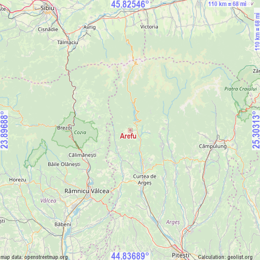
| Upper-left | 45.82546°, | 23.89688° |
| Center: | 45.33333°, | 24.6° |
| Lower-right: | 44.83689°, | 25.30313° |
| Map W x H: | 109.9×109.9 km | = 68.3×68.3mi |
| max Lat: | 48.23793° ⇑58.2% North |
| Arefu: | 45.33333° |
| min Lat: | ⇓41.8% South 43.65638° |
| min Long | Arefu | max Long |
| 20.31667° | 24.6° | 29.65403° |
| W 41.1%⇐ | ⇒58.9% E |
Elevation
Elevation of Arefu is 742 m = 2434 ft, and this is 487.1 m = 1598 ft above average elevation for this country.
| Max E: |
1278 m = 4193 ft | 2.5% |
| Arefu | 742 m 2434 ft | |
| Avg. | 254.9 m = 836 ft | |
Min E: |
-2 m = -7 ft | 97.5% |
See also: Romania elevation on elevation.city.
Geographical zone
Arefu is located in North temperate zone (between Tropic of Cancer and the Arctic Circle). Distance of this North polar circle is 2360.6 km =1466.8 mi to North.| Distance of | km | miles | from Arefu |
|---|---|---|---|
| North Pole | 4966.5 | 3086 | to North |
| Arctic Circle | 2360.6 | 1466.8 | to North |
| Tropic Cancer | 2434.7 | 1512.9 | to South |
| Equator | 5040.6 | 3132.1 | to South |


Nearby cities:
15 places around Arefu: (largest is in red/bold)
• Bucșenești
5.8 km =3.6 mi,  128°
128°
• Bărăști
8.9 km =5.5 mi,  181°
181°
• Cicănești
9.7 km =6 mi, 177°
• Corbeni
5.4 km =3.4 mi, 133°
• Căpățânenii Pământeni
4.3 km =2.7 mi,  115°
115°
• Căpățânenii Ungureni
2.6 km =1.6 mi,  90°
90°
• Oeștii Pământeni
10 km =6.2 mi,  153°
153°
• Oeștii Ungureni
9.7 km =6 mi,  156°
156°
• Poienari
4.3 km =2.7 mi, 115°
• Rotunda
6.6 km =4.1 mi,  138°
138°
• Rudeni
12.2 km =7.6 mi,  197°
197°
• Sălătrucu
6.5 km =4 mi,  270°
270°
• Urechești
8.3 km =5.2 mi,  171°
171°
• Văleni
9.2 km =5.7 mi,  212°
212°
• Şuici
10.6 km =6.6 mi, 209°
Sources, notices
• [Note1] Compared only with cities in Romania existing in our database
• [Src1] Map data: © OpenStreetMap contributors (CC-BY-SA)
• [Src2] Other city data from geonames.org with taken over terms of usage.
• [Src3] Geographical zone / Annual Mean Temperature by Robert A. Rohde @ Wikipedia
