Rotari geodata
Rotari (Prahova) is a populated place; located in Romania in Europe/Bucharest (GMT+3) time zone. With population of 894 people, there are 4644 cities with bigger population in this country. Compared to other cities in Romania, 67.5% of cities are located further ↑North; 68.7% of cities are located further ←West and 52.2% of cities have lower elevation than Rotari. Note1


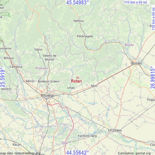
Rotari GPS coordinates[2]
45° 3' 19.008" North, 26° 17' 42.072" East
| Map corner | latitude | longitude |
|---|---|---|
| Upper-left | 45.54983°, | 25.5919° |
| Center: | 45.05528°, | 26.29502° |
| Lower-right: | 44.55642°, | 26.99815° |
| Map W x H: | 110.5×110.5 km | = 68.7×68.7mi |
| max Lat: | 48.23793° ⇑67.5% North |
| Rotari: | 45.05528° |
| min Lat: | ⇓32.5% South 43.65638° |
| min Long | Rotari | max Long |
| 20.31667° | 26.29502° | 29.65403° |
| W 68.7%⇐ | ⇒31.3% E |
Elevation
Elevation of Rotari is 223 m = 732 ft, and this is 31.9 m = 105 ft below average elevation for this country.
| Max E: |
1278 m = 4193 ft | 47.8% |
| Avg. | 254.9 m = 836 ft | |
| Rotari | 223 m = 732 ft | |
Min E: |
-2 m = -7 ft | 52.2% |
See also: Romania elevation on elevation.city.
Geographical zone
Rotari is located in North temperate zone (between Tropic of Cancer and the Arctic Circle). Distance of this North polar circle is 2391.5 km =1486 mi to North.| Distance of | km | miles | from Rotari |
|---|---|---|---|
| North Pole | 4997.4 | 3105.2 | to North |
| Arctic Circle | 2391.5 | 1486 | to North |
| Tropic Cancer | 2403.8 | 1493.7 | to South |
| Equator | 5009.7 | 3112.9 | to South |


Nearby cities:
15 places around Rotari: (largest is in red/bold)
• Ceptura de Jos
4.6 km =2.9 mi,  146°
146°
• Ceptura de Sus
4.6 km =2.9 mi,  158°
158°
• Coșerele
4.7 km =2.9 mi,  318°
318°
• Gornet-Cricov
3.8 km =2.4 mi, 324°
• Iordăcheanu
4.6 km =2.9 mi,  253°
253°
• Moceşti
3.6 km =2.2 mi,  260°
260°
• Plavia
4.9 km =3 mi,  238°
238°
• Podgoria
6 km =3.7 mi,  10°
10°
• Popești
7.5 km =4.7 mi, 320°
• Tătaru
5.8 km =3.6 mi,  31°
31°
• Ungureni
7.5 km =4.7 mi,  107°
107°
• Vadu Săpat
7.4 km =4.6 mi,  103°
103°
• Valea Cucului
5.4 km =3.4 mi,  281°
281°
• Șoimești
0.7 km =0.4 mi,  140°
140°
• Țărculești
3.9 km =2.4 mi,  298°
298°
Sources, notices
• [Note1] Compared only with cities in Romania existing in our database
• [Src1] Map data: © OpenStreetMap contributors (CC-BY-SA)
• [Src2] Other city data from geonames.org with taken over terms of usage.
• [Src3] Geographical zone / Annual Mean Temperature by Robert A. Rohde @ Wikipedia
