Gornet-Cricov geodata
Gornet-Cricov (Prahova) is a seat of a second-order administrative division; located in Romania in Europe/Bucharest (GMT+3) time zone. With population of 2,651 people, there are 2018 cities with bigger population in this country. Compared to other cities in Romania, 66.4% of cities are located further ↑North; 68.1% of cities are located further ←West and 55.6% of cities have lower elevation than Gornet-Cricov. Note1


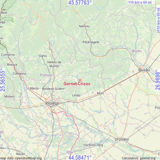
Gornet-Cricov GPS coordinates[2]
45° 4' 59.988" North, 26° 16' 0.012" East
| Map corner | latitude | longitude |
|---|---|---|
| Upper-left | 45.57763°, | 25.56355° |
| Center: | 45.08333°, | 26.26667° |
| Lower-right: | 44.58471°, | 26.9698° |
| Map W x H: | 110.4×110.4 km | = 68.6×68.6mi |
| max Lat: | 48.23793° ⇑66.4% North |
| Gornet-Cricov: | 45.08333° |
| min Lat: | ⇓33.6% South 43.65638° |
| min Long | Gornet-Cricov | max Long |
| 20.31667° | 26.26667° | 29.65403° |
| W 68.1%⇐ | ⇒31.9% E |
Elevation
Elevation of Gornet-Cricov is 241 m = 791 ft, and this is 13.9 m = 46 ft below average elevation for this country.
| Max E: |
1278 m = 4193 ft | 44.4% |
| Avg. | 254.9 m = 836 ft | |
| Gornet-Cricov | 241 m = 791 ft | |
Min E: |
-2 m = -7 ft | 55.6% |
See also: Romania elevation on elevation.city.
Geographical zone
Gornet-Cricov is located in North temperate zone (between Tropic of Cancer and the Arctic Circle). Distance of this North polar circle is 2388.4 km =1484.1 mi to North.| Distance of | km | miles | from Gornet-Cricov |
|---|---|---|---|
| North Pole | 4994.3 | 3103.3 | to North |
| Arctic Circle | 2388.4 | 1484.1 | to North |
| Tropic Cancer | 2406.9 | 1495.6 | to South |
| Equator | 5012.8 | 3114.8 | to South |


Nearby cities:
15 places around Gornet-Cricov: (largest is in red/bold)
• Apostolache
5.6 km =3.5 mi,  0°
0°
• Coșerele
1 km =0.6 mi,  297°
297°
• Iordăcheanu
4.9 km =3 mi,  206°
206°
• Moceşti
3.9 km =2.4 mi,  199°
199°
• Plavia
6 km =3.7 mi, 198°
• Podgoria
4.4 km =2.7 mi,  50°
50°
• Popești
3.7 km =2.3 mi,  315°
315°
• Rotari
3.8 km =2.4 mi,  144°
144°
• Tisa
7.4 km =4.6 mi,  40°
40°
• Tătaru
5.6 km =3.5 mi,  70°
70°
• Valea Cucului
3.6 km =2.2 mi,  236°
236°
• Valea Dulce
5.8 km =3.6 mi,  306°
306°
• Vărbila
6.8 km =4.2 mi,  233°
233°
• Șoimești
4.6 km =2.9 mi, 143°
• Țărculești
1.7 km =1.1 mi,  223°
223°
Sources, notices
• [Note1] Compared only with cities in Romania existing in our database
• [Src1] Map data: © OpenStreetMap contributors (CC-BY-SA)
• [Src2] Other city data from geonames.org with taken over terms of usage.
• [Src3] Geographical zone / Annual Mean Temperature by Robert A. Rohde @ Wikipedia
